IMAGES TAKEN NEAR TO
Drumbo Road, LISBURN, BT27 5TX
Introduction
This page details the photographs taken nearby to Drumbo Road, BT27 5TX by members of the Geograph project.
The Geograph project started in 2005 with the aim of publishing, organising and preserving representative images for every square kilometre of Great Britain, Ireland and the Isle of Man.

There are currently over 7.5m images from over14,400 individuals and you can help contribute to the project by visiting https://www.geograph.org.uk
Image Map
Images are licensed for reuse under creativecommons.org/licenses/by-sa/2.0
Notes
- Clicking on the map will re-center to the selected point.
- The higher the marker number, the further away the image location is from the centre of the postcode.
Image Listing (3 Images Found)
Images are licensed for reuse under creativecommons.org/licenses/by-sa/2.0
Image
Details
Distance
1
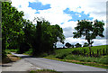
Drumbo Road near Drumbo
The Drumbo Road runs from Drumbo to the Hillhall Road. This is the view looking back towards Drumbo.
Image: © Rossographer
Taken: 12 Jun 2008
0.08 miles
2
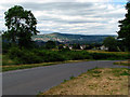
Drumbo Road near Drumbo
The view from the Drumbo Road towards Dunmurry in the distance.
Image: © Rossographer
Taken: 12 Jun 2008
0.14 miles
3
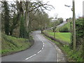
The B23 looking in the direction of Lisburn.
The white houses just visible in the distance are part of a new housing development at Gardner's Loan Ends on what used to be the site of the Homestead Inn.
Image: © Brian Shaw
Taken: 22 Mar 2007
0.19 miles