IMAGES TAKEN NEAR TO
Quarterlands Road, LISBURN, BT27 5TW
Introduction
This page details the photographs taken nearby to Quarterlands Road, BT27 5TW by members of the Geograph project.
The Geograph project started in 2005 with the aim of publishing, organising and preserving representative images for every square kilometre of Great Britain, Ireland and the Isle of Man.

There are currently over 7.5m images from over14,400 individuals and you can help contribute to the project by visiting https://www.geograph.org.uk
Image Map
Images are licensed for reuse under creativecommons.org/licenses/by-sa/2.0
Notes
- Clicking on the map will re-center to the selected point.
- The higher the marker number, the further away the image location is from the centre of the postcode.
Image Listing (5 Images Found)
Images are licensed for reuse under creativecommons.org/licenses/by-sa/2.0
Image
Details
Distance
1
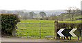
Field gate and chevrons, Ballyskeagh
A field gate on the Quarterlands Road close to Quarterlands Lane (out of picture to the right). The chevrons mark a sharp bend to the left.
Image: © Albert Bridge
Taken: 1 Mar 2014
0.11 miles
2

Letter box, Drumbeg
Pillar-mounted EIIR box, at Hambleden Park, on the Quarterlands Road Image
Image: © Albert Bridge
Taken: 21 Aug 2010
0.11 miles
3
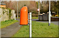
Dog bin, Ballyskeagh
A bin for dog dirt, on the Quarterlands Road, opposite Zenda Park.
Image: © Albert Bridge
Taken: 1 Mar 2014
0.13 miles
4
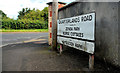
Quarterlands Road sign, Drumbeg
Comprehensive sign at the Ballyskeagh Road end of the Quarterlands Road Image I might be wrong but I understand that the name is derived from the old Scottish system of land measurement - a “quarterland” where land was assessed by value rather than by area.
Information is available on this Wiki link https://en.wikipedia.org/wiki/Markland_(Scots). Further help welcome.
Image: © Albert Bridge
Taken: 21 Aug 2010
0.17 miles
5

Blackberries, Ballyskeagh
Blackberries, at various stages of ripening, growing on the northern side of the Ballyskeagh Road, between the Quarterlands Road and the motorway bridge.
Image: © Albert Bridge
Taken: 21 Aug 2010
0.20 miles