IMAGES TAKEN NEAR TO
Tullynacross Road, LISBURN, BT27 5SL
Introduction
This page details the photographs taken nearby to Tullynacross Road, BT27 5SL by members of the Geograph project.
The Geograph project started in 2005 with the aim of publishing, organising and preserving representative images for every square kilometre of Great Britain, Ireland and the Isle of Man.

There are currently over 7.5m images from over14,400 individuals and you can help contribute to the project by visiting https://www.geograph.org.uk
Image Map
Images are licensed for reuse under creativecommons.org/licenses/by-sa/2.0
Notes
- Clicking on the map will re-center to the selected point.
- The higher the marker number, the further away the image location is from the centre of the postcode.
Image Listing (25 Images Found)
Images are licensed for reuse under creativecommons.org/licenses/by-sa/2.0
Image
Details
Distance
1
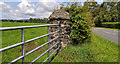
Gatepost, Lambeg
A stone gatepost, at the entrance to this field Image, on the Tullynacross Road.
Image: © Albert Bridge
Taken: 18 Jun 2011
0.02 miles
2
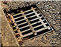
"CFL" grating cover near Lambeg
See Image This cover, also dated 1976, is one of many from the same foundry, along the Tullynacross Road, between the Lambeg Bridge Image and Sandy Lane.
Image: © Albert Bridge
Taken: 27 Oct 2012
0.03 miles
3
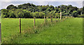
Electric fence, Lambeg
An electric fence dividing a field on the south western side of the Tullynacross Road, Lambeg.
Image: © Albert Bridge
Taken: 18 Jun 2011
0.04 miles
4
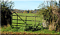
Field gate, Hilden/Lambeg
An old style of field gate beside the Tullynacross Road Image Not as common as they used to be. This Image is more or less the norm now.
Image: © Albert Bridge
Taken: 27 Oct 2012
0.06 miles
5
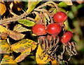
Rose hips, Hilden/Lambeg
Now past their best – rose hips beside the Tullynacross Road Image
Image: © Albert Bridge
Taken: 27 Oct 2012
0.08 miles
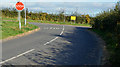
6
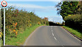
The Tullynacross Road, Lambeg/Hilden
The Tullynacross Road is a minor and twisting road. It runs from Lambeg Image via here Image to the Hillhall Road Image This view is towards Tullynacross village Image and Lambeg, from near the Hilden Road.
Image: © Albert Bridge
Taken: 27 Oct 2012
0.08 miles
7
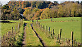
Track, Lambeg/Hilden
A farm track running west off the Tullynacross Road Image towards the Hilden Road Image Not the same as this Image
Image: © Albert Bridge
Taken: 27 Oct 2012
0.12 miles
8

Tullynacross name sign, Hilden/Lambeg (August 2016)
A townland name sign, mounted parallel to the Tullynacross Road, opposite the Hilden Road (Bridge Street on the Google map).
Image: © Albert Bridge
Taken: 29 Aug 2016
0.17 miles
9
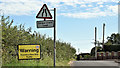
Speed limit sign, Sandy Lane, Tullynacross (August 2016)
A 40mph speed limit sign, for the duration of the work building the new service area on the inward lanes of the M1 http://www.geograph.org.uk/snippet/10200. It’s doubtful whether many (unless a rally driver) would be capable of maintaining and controlling a car, at 40, along this single-track road.
Image: © Albert Bridge
Taken: 29 Aug 2016
0.17 miles
10
The Hilden Road, Hilden (2)
Image: © Albert Bridge
Taken: 27 Oct 2012
0.18 miles