IMAGES TAKEN NEAR TO
Halftown Road, LISBURN, BT27 5RF
Introduction
This page details the photographs taken nearby to Halftown Road, BT27 5RF by members of the Geograph project.
The Geograph project started in 2005 with the aim of publishing, organising and preserving representative images for every square kilometre of Great Britain, Ireland and the Isle of Man.

There are currently over 7.5m images from over14,400 individuals and you can help contribute to the project by visiting https://www.geograph.org.uk
Image Map
Images are licensed for reuse under creativecommons.org/licenses/by-sa/2.0
Notes
- Clicking on the map will re-center to the selected point.
- The higher the marker number, the further away the image location is from the centre of the postcode.
Image Listing (16 Images Found)
Images are licensed for reuse under creativecommons.org/licenses/by-sa/2.0
Image
Details
Distance
1
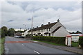
Halftown Road
Row of terraced houses on the Halftown Road. This appears to be Halftown in its entirety as my OS map has the terrace labelled as such.
Image: © Robert Ashby
Taken: 20 Oct 2013
0.08 miles
4
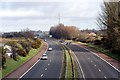
M1 Motorway
The M1 Motorway as viewed from an overbridge on the Halftown Road, looking towards Sprucefield. The exit to Sprucefield is 0.5 miles beyond the blue sign in the middle of the photo,
Image: © Wilson Adams
Taken: 17 Feb 2007
0.16 miles
5
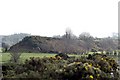
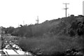
Railway Embankment
Part of the old GNRI railway embankment that once carried the railway from Knockmore Junction to Banbridge and Newcastle.
Image: © Wilson Adams
Taken: 17 Feb 2007
0.16 miles
6
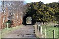
Access Path
The original entrance from the Culcavey Rd, that led to Eglantine All Saints Church. When the railway embankment was built, a tunnel was provided for the parishioners to gain access to the church. The farmer has removed part of the embankment on the lefthand side of the image to gain an extra couple of acres of grazing land for cattle.
Image: © Wilson Adams
Taken: 18 Feb 2007
0.16 miles
7
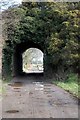
A Railway Tunnel
The original entrance from the Culcavey Rd, that led to Eglantine All Saints Church. When the railway embankment was built, a tunnel was provided for the parishioners to gain access to the church. The farmer has removed part of the embankment on the lefthand side of the image to gain an extra couple of acres of grazing land for cattle.
Image: © Wilson Adams
Taken: 18 Feb 2007
0.16 miles
8
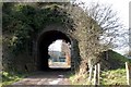
A Railway Tunnel
A view from the other side of the railway embankment looking towards the Culcavey Road, and the rear of Newport Primary School. The farmer has removed the embankment on the right-hand side of the image to gain an extra couple of acres of grazing land for cattle.
Image: © Wilson Adams
Taken: 18 Feb 2007
0.16 miles
9
Railway Embankment
The railway embankment at Newport, looking towards Hillsborough
Image: © Wilson Adams
Taken: 18 Feb 2007
0.16 miles
10
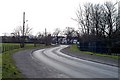
The Culcavey Rd
The Culcavey Rd, Newport, that leads to Hillsborough. The houses in the centre of the photo are in grid J2461.
Image: © Wilson Adams
Taken: 18 Feb 2007
0.16 miles