IMAGES TAKEN NEAR TO
Blaris Road, LISBURN, BT27 5RA
Introduction
This page details the photographs taken nearby to Blaris Road, BT27 5RA by members of the Geograph project.
The Geograph project started in 2005 with the aim of publishing, organising and preserving representative images for every square kilometre of Great Britain, Ireland and the Isle of Man.

There are currently over 7.5m images from over14,400 individuals and you can help contribute to the project by visiting https://www.geograph.org.uk
Image Map
Images are licensed for reuse under creativecommons.org/licenses/by-sa/2.0
Notes
- Clicking on the map will re-center to the selected point.
- The higher the marker number, the further away the image location is from the centre of the postcode.
Image Listing (10 Images Found)
Images are licensed for reuse under creativecommons.org/licenses/by-sa/2.0
Image
Details
Distance
1
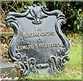
Edward T Fitzpatrick grave marker, Blaris Old Burial Ground, Lisburn
There are several cast-iron grave markers in the graveyard. This one, which has the inscription “THE BURYING GROUND OF EDWARD T FITPATRICK”, has been painted recently with the letters picked out in gold. Some have the foundry name on the back but not in this case though it looks like a product of the Millfield Foundry, Belfast.
Image: © Albert Bridge
Taken: 27 Sep 2014
0.12 miles
2
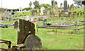
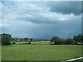
Blaris Old Burial Ground, Lisburn - September 2014(2)
The south western end of the graveyard.
Image: © Albert Bridge
Taken: 27 Sep 2014
0.12 miles
3
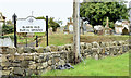
Blaris Old Burial Ground, Lisburn - September 2014(1)
The outside of the graveyard facing the Blaris Road.
Image: © Albert Bridge
Taken: 27 Sep 2014
0.12 miles
4
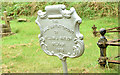
William J Watson grave marker, Blaris Old Burial Ground, Lisburn (1)
A cast-iron grave marker with the inscription “THE FAMILY BURYING GROUND OF WILLIAM J WATSON BELFAST 1928”. This one was made by Combe Barbour of Belfast – a business which traded (1845/1955) as The Falls Foundry from Second Street, off the Falls Road The date is interesting, showing that the manufacture of such products continued well into the 20th century. The foundry was, perhaps, better known for the production of textile machinery. Image shows the maker’s name.
Image: © Albert Bridge
Taken: 27 Sep 2014
0.13 miles
5
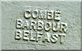
William J Watson grave marker, Blaris Old Burial Ground, Lisburn (2)
See Image The maker’s name “Combe Barbour Belfast” on the back.
Image: © Albert Bridge
Taken: 27 Sep 2014
0.13 miles
6
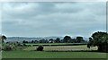
Farmland immediately west of Blaris Cemetery
Image: © Eric Jones
Taken: 4 Jun 2016
0.16 miles
9
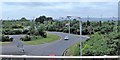
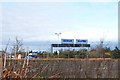
The A101 at Junction 8 of the M1
The image was taken from the M1. Behind the screen of trees is the car park of the Lisburn Sprucefield Park and Ride.
Image: © Eric Jones
Taken: 4 Jun 2016
0.24 miles
10

The M1 at Sprucefield (2)
See Image Approaching the M1 from the south there are three roundabouts on the signposted route to Belfast. This is the last. The junction is no 8. Continue to Image
Image: © Albert Bridge
Taken: 25 Apr 2009
0.25 miles