IMAGES TAKEN NEAR TO
Lisnoe Road, LISBURN, BT27 5LT
Introduction
This page details the photographs taken nearby to Lisnoe Road, BT27 5LT by members of the Geograph project.
The Geograph project started in 2005 with the aim of publishing, organising and preserving representative images for every square kilometre of Great Britain, Ireland and the Isle of Man.

There are currently over 7.5m images from over14,400 individuals and you can help contribute to the project by visiting https://www.geograph.org.uk
Image Map
Images are licensed for reuse under creativecommons.org/licenses/by-sa/2.0
Notes
- Clicking on the map will re-center to the selected point.
- The higher the marker number, the further away the image location is from the centre of the postcode.
Image Listing (6 Images Found)
Images are licensed for reuse under creativecommons.org/licenses/by-sa/2.0
Image
Details
Distance
1
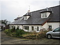
B & B
Lisnoe Old Farmhouse Bed & Breakfast.
Image: © Brian Shaw
Taken: 9 Jan 2006
0.11 miles
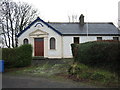
4
The Lisnoe Road near Ravernet
The Lisnoe Road is a minor road connecting Ravernet and Duneight.
Image: © Albert Bridge
Taken: 6 Apr 2008
0.17 miles
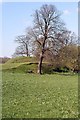
5
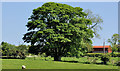
Tree, Ravernet near Lisburn
A solitary tree, which might have started life as part of a hedge, in a field beside the Lisnoe Road, seen from the Legacurry Road Image
Image: © Albert Bridge
Taken: 27 May 2012
0.21 miles
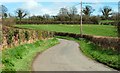
6
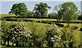
Fields and trees, Ravernet near Lisburn
Fields, trees and hawthorn blossom between the Lisnoe Image and Green Roads.
Image: © Albert Bridge
Taken: 27 May 2012
0.21 miles