
IMAGES TAKEN NEAR TO
Alanbrooke Avenue, LISBURN, BT27 5HS
Introduction
This page details the photographs taken nearby to Alanbrooke Avenue, BT27 5HS by members of the Geograph project.
The Geograph project started in 2005 with the aim of publishing, organising and preserving representative images for every square kilometre of Great Britain, Ireland and the Isle of Man.

There are currently over 7.5m images from over14,400 individuals and you can help contribute to the project by visiting https://www.geograph.org.uk
Image Map
Images are licensed for reuse under creativecommons.org/licenses/by-sa/2.0
Notes
- Clicking on the map will re-center to the selected point.
- The higher the marker number, the further away the image location is from the centre of the postcode.
Image Listing (53 Images Found)
Images are licensed for reuse under creativecommons.org/licenses/by-sa/2.0
Image
Details
Distance
1
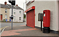
Pillar box, Lisburn
EIIR pillar box, at the corner of Mercer Street and Sloan Street (background).
Image: © Albert Bridge
Taken: 21 Aug 2011
0.10 miles
2
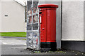
Pillar box, Lisburn
EIIR pillar box, on the Hillsborough Old Road, at the corner of the Ballynahinch Road.
Image: © Albert Bridge
Taken: 4 Dec 2011
0.11 miles
3
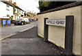
Cromwell's Highway sign, Lisburn
A street off the Saintfield Road named after the general and Lord Protector. Other streets in the area are also named after generals (Templar, Dill, Alanbrooke).
Image: © Albert Bridge
Taken: 4 Dec 2011
0.11 miles
4
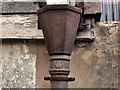
Drainpipe, Lisburn
A rusty drainpipe, in this entry Image, off Sloan Street. It has a fancy “C” on the down pipe which might be a foundry trademark.
Image: © Albert Bridge
Taken: 21 Aug 2011
0.11 miles
5
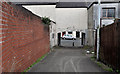
Entry, Lisburn
An entry running from Gregg Street Mews to Sloan Street (background).
Image: © Albert Bridge
Taken: 21 Aug 2011
0.11 miles
6
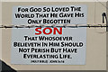
Biblical message, Lisburn
A familiar message, on a gable wall, almost opposite Mercer Street.
Image: © Albert Bridge
Taken: 4 Aug 2013
0.11 miles
7
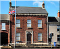
No 2 Graham Place, Lisburn
A large house, at the end of Sloan Street. On the “At Risk” register which describes it as:
“A rather unassuming, two-storey, red-brick townhouse, thought to date from the 1840s. It retains much of its original character and appearance, although the surroundings have undoubtedly changed beyond recognition. While being far from dereliction, the building does appear to be unused, and could benefit greatly from some timely repair”.
Note: this photograph appears as a matter of record only and should not be interpreted as an expression, by me, of any criticism of the owner or his/her standards of maintenance.
Image: © Albert Bridge
Taken: 11 Jul 2010
0.11 miles
8

Ava Street, Lisburn
A short street off Young Street (the name under which it appears on the Google map). In the Belfast Metropolitan Area Plan to 2015 it comes under the description “There are a number of established residential areas at the above locations in Lisburn City Centre, and the Department recognises the importance of maintaining these communities.”
Image: © Albert Bridge
Taken: 24 Aug 2010
0.12 miles
9
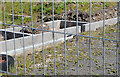
Vacant development site, Lisburn (2013-2)
See Image Foundations beside the Ballynahinch Road. There are other bits of uncompleted work elsewhere on the site.
Image: © Albert Bridge
Taken: 4 Aug 2013
0.12 miles
10
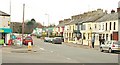
The Hillsborough Old Road, Lisburn
Before the horseless carriage and the building of the present line Image this was the main road to Hillsborough and Dublin. It rejoins the present road near Image The Ballynahinch Road Image is at bottom left. Continue to Image
Image: © Albert Bridge
Taken: 18 Feb 2009
0.13 miles