IMAGES TAKEN NEAR TO
Hollybrook Hill, LISBURN, BT27 5GB
Introduction
This page details the photographs taken nearby to Hollybrook Hill, BT27 5GB by members of the Geograph project.
The Geograph project started in 2005 with the aim of publishing, organising and preserving representative images for every square kilometre of Great Britain, Ireland and the Isle of Man.

There are currently over 7.5m images from over14,400 individuals and you can help contribute to the project by visiting https://www.geograph.org.uk
Image Map
Images are licensed for reuse under creativecommons.org/licenses/by-sa/2.0
Notes
- Clicking on the map will re-center to the selected point.
- The higher the marker number, the further away the image location is from the centre of the postcode.
Image Listing (17 Images Found)
Images are licensed for reuse under creativecommons.org/licenses/by-sa/2.0
Image
Details
Distance
1
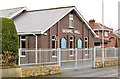
Plantation gospel hall, Lisburn
Gospel hall on the Plantation Road. I cannot find an opening or building date but, at the end of WW1, the only hall listed in the town directory was the one at Wallace Avenue Image
Image: © Albert Bridge
Taken: 26 Dec 2012
0.11 miles
2
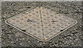
"HRDC" access cover, Lisburn (3)
A Hillsborough Rural District Council access cover on Image on the Plantation Road.
Image: © Albert Bridge
Taken: 26 Dec 2012
0.14 miles
3
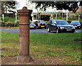
Boundary post, Lisburn (2)
See Image and Image Another Lisburn town boundary post. This one is on the Plantation Road close to the Saintfield Road.
Image: © Albert Bridge
Taken: 10 Apr 2012
0.19 miles
4
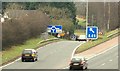
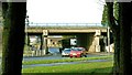
Motorway junction, Lisburn (7)
See Image The southbound off slip for traffic for Lisburn and Saintfield.
Image: © Albert Bridge
Taken: 18 Feb 2009
0.19 miles
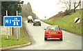
5
Motorway junction, Lisburn (1)
Officially Junction 6 on the M1 but more commonly known as “The Saintfield turn-off” there is a busy roundabout on the Lisburn – Saintfield road. This is the flyover and the north eastern side of the roundabout seen from the Saintfield side. Continue to Image
Image: © Albert Bridge
Taken: 3 Feb 2009
0.20 miles
6

M1 roadworks, Lisburn/Sprucefield
Work is underway strengthening the flyover Image and Image at Sprucefield. Outward traffic is using the hard shoulder and inside lane. Inward traffic is using the overtaking lane of the outward carriageway except that joining at Sprucefield which uses the inside lane of the inward carriageway. The view is outward from the Hillhall Road bridge.
Image: © Albert Bridge
Taken: 3 Jun 2010
0.20 miles
7
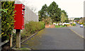
Letter box, Lisburn
Post-mounted EIIR letter box (BT27 98), on the Plantation Road, close to Holborn Hall (middle background).
Image: © Albert Bridge
Taken: 10 Apr 2012
0.20 miles
8
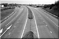
The M1 at Lisburn (1980)
The M1, at Lisburn, looking towards Dungannon from the Hillhall Road bridge, in 1980. Note the gap (now closed) in the central reservation. This was intended for use by the emergency services but some naughty drivers used it too. For a more recent view see Image
Image: © Albert Bridge
Taken: 25 May 1980
0.21 miles
9
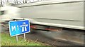
Motorway junction, Lisburn (5)
Image: © Albert Bridge
Taken: 3 Feb 2009
0.22 miles
10
Motorway junction, Lisburn (2)
Image: © Albert Bridge
Taken: 3 Feb 2009
0.23 miles