IMAGES TAKEN NEAR TO
Ballantine Gardens, LISBURN, BT27 5FJ
Introduction
This page details the photographs taken nearby to Ballantine Gardens, BT27 5FJ by members of the Geograph project.
The Geograph project started in 2005 with the aim of publishing, organising and preserving representative images for every square kilometre of Great Britain, Ireland and the Isle of Man.

There are currently over 7.5m images from over14,400 individuals and you can help contribute to the project by visiting https://www.geograph.org.uk
Image Map
Images are licensed for reuse under creativecommons.org/licenses/by-sa/2.0
Notes
- Clicking on the map will re-center to the selected point.
- The higher the marker number, the further away the image location is from the centre of the postcode.
Image Listing (27 Images Found)
Images are licensed for reuse under creativecommons.org/licenses/by-sa/2.0
Image
Details
Distance
1
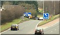
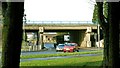
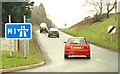
Motorway junction, Lisburn (7)
See Image The southbound off slip for traffic for Lisburn and Saintfield.
Image: © Albert Bridge
Taken: 18 Feb 2009
0.10 miles
2
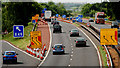
M1 roadworks, Lisburn/Sprucefield
Work is underway strengthening the flyover Image and Image at Sprucefield. Outward traffic is using the hard shoulder and inside lane. Inward traffic is using the overtaking lane of the outward carriageway except that joining at Sprucefield which uses the inside lane of the inward carriageway. The view is outward from the Hillhall Road bridge.
Image: © Albert Bridge
Taken: 3 Jun 2010
0.11 miles
3
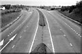
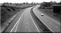
The M1 at Lisburn (1980)
The M1, at Lisburn, looking towards Dungannon from the Hillhall Road bridge, in 1980. Note the gap (now closed) in the central reservation. This was intended for use by the emergency services but some naughty drivers used it too. For a more recent view see Image
Image: © Albert Bridge
Taken: 25 May 1980
0.12 miles
4
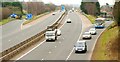
Motorway junction, Lisburn (6)
Image: © Albert Bridge
Taken: 18 Feb 2009
0.14 miles
5
"HRDC" access cover, Lisburn (3)
A Hillsborough Rural District Council access cover on Image on the Plantation Road.
Image: © Albert Bridge
Taken: 26 Dec 2012
0.15 miles
6
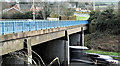
M1 bridge, Hillhall Road, Lisburn (March 2017)
This view of the flyover carrying the Hillhall Road Image across the M1 was previously blocked by embankment trees - now removed (remains in the foreground). Belfast is to the left.
Image: © Albert Bridge
Taken: 11 Mar 2017
0.15 miles
7
Motorway junction, Lisburn (1)
Officially Junction 6 on the M1 but more commonly known as “The Saintfield turn-off” there is a busy roundabout on the Lisburn – Saintfield road. This is the flyover and the north eastern side of the roundabout seen from the Saintfield side. Continue to Image
Image: © Albert Bridge
Taken: 3 Feb 2009
0.15 miles
8
The M1, Lisburn (2 in 1980)
See Image The view, towards Belfast along a deserted M1, from the Hillhall Road bridge on the same day.
Image: © Albert Bridge
Taken: 25 May 1980
0.16 miles
9
Motorway junction, Lisburn (2)
Image: © Albert Bridge
Taken: 3 Feb 2009
0.16 miles
10
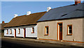
Thatched cottages, Lisburn (2)
This slide had been filed away, in a box, unprojected since it was taken in 1982. I’d completely forgotten that there was another cottage, with corrugated metal roof, adjacent to the one seen in Image It was subsequently restored and thatched. Use the number of chimneys as a common reference.
Image: © Albert Bridge
Taken: 11 Sep 1982
0.17 miles