IMAGES TAKEN NEAR TO
Ashmount Park, LISBURN, BT27 5DG
Introduction
This page details the photographs taken nearby to Ashmount Park, BT27 5DG by members of the Geograph project.
The Geograph project started in 2005 with the aim of publishing, organising and preserving representative images for every square kilometre of Great Britain, Ireland and the Isle of Man.

There are currently over 7.5m images from over14,400 individuals and you can help contribute to the project by visiting https://www.geograph.org.uk
Image Map
Images are licensed for reuse under creativecommons.org/licenses/by-sa/2.0
Notes
- Clicking on the map will re-center to the selected point.
- The higher the marker number, the further away the image location is from the centre of the postcode.
Image Listing (47 Images Found)
Images are licensed for reuse under creativecommons.org/licenses/by-sa/2.0
Image
Details
Distance
1
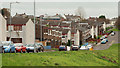
Ashmount Gardens, Lisburn
Part of the Hillhall estate, overlooking the Lagan.
Image: © Albert Bridge
Taken: 22 Nov 2009
0.05 miles
2
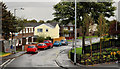
Hillhall Gardens, Lisburn
Hillhall Gardens is part of the Hillhall estate Image It runs from the Hillhall Road Image to Meeting House Lane Image
Image: © Albert Bridge
Taken: 20 Sep 2011
0.10 miles
3
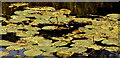
Water lilies, Lisburn
Water lilies on the Lagan, some of which are starting to flower, seen, through a rare gap in the trees, from Image
Image: © Albert Bridge
Taken: 13 Jul 2011
0.12 miles
4
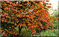
Autumn chestnuts, Lisburn
Horse chestnut trees, along the Lagan towpath, between the Union and Moore’s Bridges, showing their autumn colours.
Image: © Albert Bridge
Taken: 2 Oct 2011
0.13 miles
5
Drop box, Lisburn
Image: © Albert Bridge
Taken: 20 Sep 2011
0.13 miles
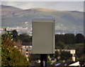
6
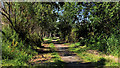
Riverside path, Lisburn
Part of a path beside the Lagan – behind the trees on the left in Image
Image: © Albert Bridge
Taken: 13 Jul 2011
0.14 miles
7
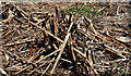
Japanese knotweed, Lisburn
There was a considerable growth of the invasive Japanese knotweed along this path Image Some remains but most seems to have been destroyed – possibly by using an approved herbicide.
Image: © Albert Bridge
Taken: 13 Jul 2011
0.14 miles
8
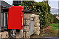
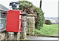
Letter box, Lisburn
EIIR letter box, mounted on a concrete post, at the Hillhall Road end of Meeting House Lane Image Now replaced by a pressed-steel box Image
Image: © Albert Bridge
Taken: 20 Sep 2011
0.14 miles
9
Pressed-steel postbox (BT27 19D), Lisburn (March 2017)
Post-mounted pressed-steel postbox (BT27 19D) at Meeting House Lane. It replaced this one Image (BT27 19).
Image: © Albert Bridge
Taken: 11 Mar 2017
0.14 miles
10
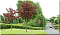
Meeting House Lane, Lisburn
Meeting House Lane now forms the boundary between the countryside (or what’s left of it) and Lisburn. The Hillhall estate is on the right.
Image: © Albert Bridge
Taken: 21 May 2009
0.14 miles