IMAGES TAKEN NEAR TO
Plantation Drive, LISBURN, BT27 5BJ
Introduction
This page details the photographs taken nearby to Plantation Drive, BT27 5BJ by members of the Geograph project.
The Geograph project started in 2005 with the aim of publishing, organising and preserving representative images for every square kilometre of Great Britain, Ireland and the Isle of Man.

There are currently over 7.5m images from over14,400 individuals and you can help contribute to the project by visiting https://www.geograph.org.uk
Image Map
Images are licensed for reuse under creativecommons.org/licenses/by-sa/2.0
Notes
- Clicking on the map will re-center to the selected point.
- The higher the marker number, the further away the image location is from the centre of the postcode.
Image Listing (33 Images Found)
Images are licensed for reuse under creativecommons.org/licenses/by-sa/2.0
Image
Details
Distance
1
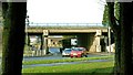
Motorway junction, Lisburn (1)
Officially Junction 6 on the M1 but more commonly known as “The Saintfield turn-off” there is a busy roundabout on the Lisburn – Saintfield road. This is the flyover and the north eastern side of the roundabout seen from the Saintfield side. Continue to Image
Image: © Albert Bridge
Taken: 3 Feb 2009
0.03 miles
2
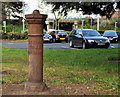
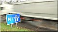
Boundary post, Lisburn (2)
See Image and Image Another Lisburn town boundary post. This one is on the Plantation Road close to the Saintfield Road.
Image: © Albert Bridge
Taken: 10 Apr 2012
0.06 miles
3
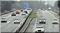
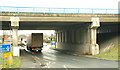
The M1, Lisburn - March 2017(2)
The M1 inward lanes and hard shoulder (right), looking towards Sprucefield, seen from the Hillhall Road overbridge. There are gaps in the shoulder (and, hence, in the proposed bus lane) to accommodate the slip roads. For a comparison in the volume of traffic see this view Image in May 1980.
Image: © Albert Bridge
Taken: 11 Mar 2017
0.07 miles
4
Motorway junction, Lisburn (2)
Image: © Albert Bridge
Taken: 3 Feb 2009
0.07 miles
5
Motorway junction, Lisburn (5)
Image: © Albert Bridge
Taken: 3 Feb 2009
0.08 miles
6
Motorway junction, Lisburn (4)
Image: © Albert Bridge
Taken: 3 Feb 2009
0.08 miles
7
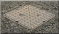
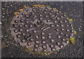
"HRDC" access cover, Lisburn (3)
A Hillsborough Rural District Council access cover on Image on the Plantation Road.
Image: © Albert Bridge
Taken: 26 Dec 2012
0.08 miles
8
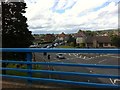
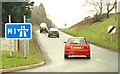
Roundabout at Saintfield Road, seen from the M1
Image: © Darrin Antrobus
Taken: 2 Aug 2013
0.08 miles
9
"SW" manhole cover, Lisburn
One of two anonymous manhole covers, marked “SW” (surface water) at Largymore Link. This one is close to the M1 roundabout Image
Image: © Albert Bridge
Taken: 20 Sep 2011
0.10 miles
10
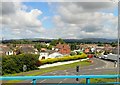
Saintsfield Road, Lisburn viewed from the M1
Image: © Eric Jones
Taken: 21 Jun 2019
0.11 miles