IMAGES TAKEN NEAR TO
Parkview, LISBURN, BT27 4XY
Introduction
This page details the photographs taken nearby to Parkview, BT27 4XY by members of the Geograph project.
The Geograph project started in 2005 with the aim of publishing, organising and preserving representative images for every square kilometre of Great Britain, Ireland and the Isle of Man.

There are currently over 7.5m images from over14,400 individuals and you can help contribute to the project by visiting https://www.geograph.org.uk
Image Map
Images are licensed for reuse under creativecommons.org/licenses/by-sa/2.0
Notes
- Clicking on the map will re-center to the selected point.
- The higher the marker number, the further away the image location is from the centre of the postcode.
Image Listing (108 Images Found)
Images are licensed for reuse under creativecommons.org/licenses/by-sa/2.0
Image
Details
Distance
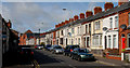
1
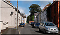
Wilson Street, Hilden
A street, running south, off the Low Road Image (background).
Image: © Albert Bridge
Taken: 12 Sep 2010
0.05 miles
2
The Low Road, Hilden (2)
See Image The Low Road looking, in the opposite direction, towards Grand Street.
Image: © Albert Bridge
Taken: 25 Apr 2011
0.06 miles
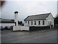
3
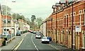
Wesley Street, Lisburn
A continuation of the Millbrook Road Image towards the Low Road and Hilden.
Image: © Albert Bridge
Taken: 3 Feb 2009
0.08 miles
4
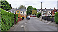
Barley Hill, Lisburn (1)
A street running from the Low Road Image (background) to Roseville Walk. The hedges hide some prefab bungalows which are probably in better condition than when built.
Image: © Albert Bridge
Taken: 25 Apr 2011
0.09 miles
5
The Low Road, Hilden
The continuation of Wesley Street Image (background) towards Hilden.
Image: © Albert Bridge
Taken: 12 Sep 2010
0.09 miles
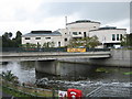
6
The Point, Lisburn
A modern Bar/Grill viewed across the river Lagan from Union Bridge.
Image: © Brian Shaw
Taken: 5 Oct 2005
0.10 miles
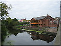
7
The Island Civic Centre
Situated on an island between the river Lagan (foreground) and the Lagan Navigation canal, this houses the main offices of Lisburn City Council.
Image: © Brian Shaw
Taken: 12 Oct 2005
0.10 miles
9
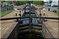
Lisburn lock, disused Lagan Navigation
The Lagan Navigation was formally abandoned in 1954. Most of it is overgrown but the lock at Lisburn has been restored. It is now the starting point for short trips upstream on the River Lagan in the “Lagan Belle” Image a replica narrow boat. This is the view from the Belfast end.
Image: © Albert Bridge
Taken: 3 Jul 2006
0.10 miles
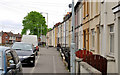
10
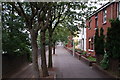
Hancock Street, Lisburn
Hancock Street was named after John Hancock, a Lisburn member of the Society of Friends, who was involved in the linen trade. The original Hancock Street included a number of substantial houses but my memory of it from the early 70’s is of dereliction. This is the present street (River Lagan on the left) which shows that public sector housing can be attractive, imaginative and blend with its surroundings.
Image: © Albert Bridge
Taken: 4 Jul 2006
0.10 miles