IMAGES TAKEN NEAR TO
Victory Street, LISBURN, BT27 4TP
Introduction
This page details the photographs taken nearby to Victory Street, BT27 4TP by members of the Geograph project.
The Geograph project started in 2005 with the aim of publishing, organising and preserving representative images for every square kilometre of Great Britain, Ireland and the Isle of Man.

There are currently over 7.5m images from over14,400 individuals and you can help contribute to the project by visiting https://www.geograph.org.uk
Image Map
Images are licensed for reuse under creativecommons.org/licenses/by-sa/2.0
Notes
- Clicking on the map will re-center to the selected point.
- The higher the marker number, the further away the image location is from the centre of the postcode.
Image Listing (30 Images Found)
Images are licensed for reuse under creativecommons.org/licenses/by-sa/2.0
Image
Details
Distance
1
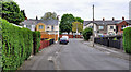
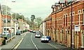
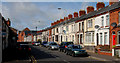
Barley Hill, Lisburn (1)
A street running from the Low Road Image (background) to Roseville Walk. The hedges hide some prefab bungalows which are probably in better condition than when built.
Image: © Albert Bridge
Taken: 25 Apr 2011
0.10 miles
2
The Low Road, Hilden (2)
See Image The Low Road looking, in the opposite direction, towards Grand Street.
Image: © Albert Bridge
Taken: 25 Apr 2011
0.10 miles
3
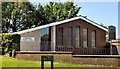
Forthill gospel hall. Lisburn
The hall, on the Low Road, opened in 1979. Before that meetings were held in rooms in the town centre.
Image: © Albert Bridge
Taken: 13 Jul 2011
0.10 miles
4
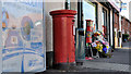
Pillar box, Hilden
GR pillar box, at Grand Street, close to Leamington Place.
Image: © Albert Bridge
Taken: 13 Jul 2011
0.12 miles
5
Wesley Street, Lisburn
A continuation of the Millbrook Road Image towards the Low Road and Hilden.
Image: © Albert Bridge
Taken: 3 Feb 2009
0.18 miles
6
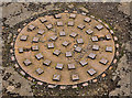
"Needham" manhole cover, Hilden, Lisburn
A Needham (Stockport) manhole cover at Huguenot Drive. Image and Image show other products from the same foundry.
Image: © Albert Bridge
Taken: 23 Feb 2012
0.18 miles
7
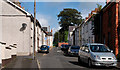
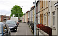
Wilson Street, Hilden
A street, running south, off the Low Road Image (background).
Image: © Albert Bridge
Taken: 12 Sep 2010
0.18 miles
8
Delacherois Avenue, Hilden, Lisburn
A street, off Grand Street, enhanced by tree planting. The name recalls the Huguenots Image who settled in Lisburn and were, in part, responsible for the development of the local linen industry.
Image: © Albert Bridge
Taken: 1 Dec 2012
0.19 miles
9
The Low Road, Hilden
The continuation of Wesley Street Image (background) towards Hilden.
Image: © Albert Bridge
Taken: 12 Sep 2010
0.19 miles
10
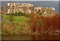
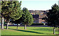
Flats, Lisburn
Flats, overlooking the Lagan at Huguenot Drive, bathed in a light which was a warning of the coming stormy weather.
Image: © Albert Bridge
Taken: 22 Nov 2009
0.21 miles