IMAGES TAKEN NEAR TO
Church Hill, LISBURN, BT27 4SB
Introduction
This page details the photographs taken nearby to Church Hill, BT27 4SB by members of the Geograph project.
The Geograph project started in 2005 with the aim of publishing, organising and preserving representative images for every square kilometre of Great Britain, Ireland and the Isle of Man.

There are currently over 7.5m images from over14,400 individuals and you can help contribute to the project by visiting https://www.geograph.org.uk
Image Map
Images are licensed for reuse under creativecommons.org/licenses/by-sa/2.0
Notes
- Clicking on the map will re-center to the selected point.
- The higher the marker number, the further away the image location is from the centre of the postcode.
Image Listing (37 Images Found)
Images are licensed for reuse under creativecommons.org/licenses/by-sa/2.0
Image
Details
Distance
1
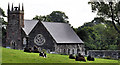
Lambeg (CoI) parish church (2)
Image: © Albert Bridge
Taken: 18 Jun 2011
0.02 miles
2
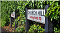
Road name signs, Lambeg
Two signs showing the townland as Lambeg North and the change of name from Lambeg Road to Church Hill Image The latter continues towards Ballyskeagh becoming the Ballyskeagh Road a short distance further along.
Image: © Albert Bridge
Taken: 18 Jun 2011
0.03 miles
3
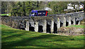
Wolfenden's Bridge, Lambeg (2)
See Image The view across the bridge, towards Lambeg, from the Ballyskeagh/Drumbeg end. The Lagan flows from left to right at bottom left.
Image: © Albert Bridge
Taken: 18 Jun 2011
0.07 miles
4
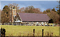
Lambeg (CoI) parish church, Lambeg
Image: © Albert Bridge
Taken: 22 Feb 2010
0.08 miles
5
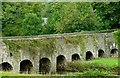
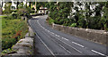
Wolfenden's Bridge, Lambeg
An early 19th century bridge, carrying the road from Lambeg to Drumbeg across the Lagan. It replaced a ford. The Wolfendens were a linen family originally from Holland or what is now Belgium. The view is towards Drumbeg.
Image: © Albert Bridge
Taken: 12 Sep 2008
0.09 miles
6
Wolfenden's Bridge, Lambeg
See the earlier image of the bridge at Image Described as "a masonry bridge of 9 small arches, built pre-1833 which carries the Ballyskeagh Road over the Lagan near Lambeg Village. It is named after one of the pioneers of the Linen industry" (from http://www.laganvalley.co.uk/places-to-visit/bridges.html ). The Wolfenden family are buried in the nearby churchyard Image
Image: © Rossographer
Taken: 9 Mar 2011
0.09 miles
7
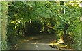
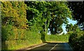
The Lambeg Road, Lambeg (2)
See Image The view towards Lambeg where the road passes through a tunnel of trees. Continue to Image
Image: © Albert Bridge
Taken: 3 Oct 2008
0.11 miles
8
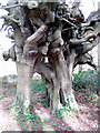
John Wesley's beech trees, Lambeg, Co. Down
These trees stand at the entrance to Chrome Hill, just north of Wolfenden's Bridge on the Lambeg-Ballyskeagh road. During one of his visits to Ireland in the late 18th century, John Wesley stayed at Chrome Hill. He twisted together two beech saplings as a symbol of the friendship of the Methodist Church and the Church of Ireland, and the trees still stand today.
Image: © Alex Cameron
Taken: 31 Mar 2006
0.12 miles
9
The Lambeg Road, Lambeg (1)
The Lambeg Road is a ”B” road running from Lambeg to Drumbeg. Once past Lambeg it remains remained rural. The view is towards Drumbeg and Wolfenden’s Bridge Image See also Image
Image: © Albert Bridge
Taken: 3 Oct 2008
0.12 miles
10
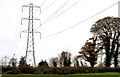
Pylon and power lines near Lambeg (2)
Pylon and power lines, seen from the towpath near Lambeg. This is the grid after Image] running in the direction of Image
Image: © Albert Bridge
Taken: 5 Nov 2010
0.13 miles