IMAGES TAKEN NEAR TO
Station Road, LISBURN, BT27 4QD
Introduction
This page details the photographs taken nearby to Station Road, BT27 4QD by members of the Geograph project.
The Geograph project started in 2005 with the aim of publishing, organising and preserving representative images for every square kilometre of Great Britain, Ireland and the Isle of Man.

There are currently over 7.5m images from over14,400 individuals and you can help contribute to the project by visiting https://www.geograph.org.uk
Image Map
Images are licensed for reuse under creativecommons.org/licenses/by-sa/2.0
Notes
- Clicking on the map will re-center to the selected point.
- The higher the marker number, the further away the image location is from the centre of the postcode.
Image Listing (109 Images Found)
Images are licensed for reuse under creativecommons.org/licenses/by-sa/2.0
Image
Details
Distance
1
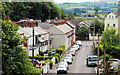
Station Road, Lambeg (2)
See Image Looking in the opposite direction (from the station footbridge Image) with a view of the still-undeveloped fields of the Lagan valley in the background.
Image: © Albert Bridge
Taken: 21 Jul 2010
0.01 miles
2
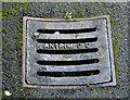
Antrim County Council gully grating, Lambeg
An Antrim County Council gully grating cover, near the Lambeg Road end of the Station Road Image NI county councils were abolished in 1973 upon reorganisation of local government. See also Image
Image: © Albert Bridge
Taken: 2 Jan 2014
0.03 miles
3
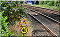
Temporary speed restriction sign, Lambeg station
Sign, at the Lisburn end of Lambeg station, warning of a temporary speed restriction further along the line. Image shows the sign used for a permanent speed limit.
Image: © Albert Bridge
Taken: 21 Jul 2010
0.05 miles
4
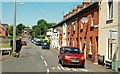
Station Road, Lambeg
Station Road leads from the Lambeg Road to the station Image at the end of the road. The terrace on the right is Railway View. Image shows the view in the opposite direction.
Image: © Albert Bridge
Taken: 24 Jun 2009
0.05 miles
5
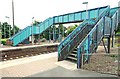
Footbridge, Lambeg station
The footbridge at the Lisburn end of Lambeg station Image The down (Belfast-bound) platform is in the foreground. The bridge also connects Queensway Image and the Station Road Image
Image: © Albert Bridge
Taken: 20 Jul 2009
0.05 miles
6
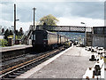
Train entering Lambeg station
During a period of single line working for track renewal, a former GNR(B) built DMU enters Lambeg station with a train from Lisburn to Belfast. After Northern Ireland Railways withdrew staff from the smaller halts in 1969, the GNR station buildings were quickly demolished, being replaced with the brick structure seen on the right.
Image: © The Carlisle Kid
Taken: Unknown
0.05 miles
7
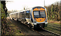
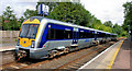
Train, Lambeg (1 in 2014)
C3K set 3010 departing Lambeg, into the low winter sun, with the 10.57 Bangor – Portadown.
Image: © Albert Bridge
Taken: 2 Jan 2014
0.06 miles
8
Train, Lambeg station (2)
Image: © Albert Bridge
Taken: 20 Jul 2009
0.06 miles
9
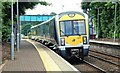
Lambeg station (4)
The 10.45 Portadown – Bangor calling at Lambeg. This stock (built in Spain by CAF - Construcciones y Auxiliar de Ferrocarriles) is probably the most attractive ever operated in NI.
Image: © Albert Bridge
Taken: 21 Jul 2010
0.06 miles
10
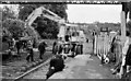
Re-sleepering, Lambeg station
See Image 18 years before the previous photograph, a rail/road crane is assisting in re-sleepering the up line at Lambeg station. This was in the days before high-visibility clothing. The only headgear in use is a duncher.
Image: © Albert Bridge
Taken: 25 May 1980
0.06 miles