IMAGES TAKEN NEAR TO
Woodland Park, LISBURN, BT27 4PG
Introduction
This page details the photographs taken nearby to Woodland Park, BT27 4PG by members of the Geograph project.
The Geograph project started in 2005 with the aim of publishing, organising and preserving representative images for every square kilometre of Great Britain, Ireland and the Isle of Man.

There are currently over 7.5m images from over14,400 individuals and you can help contribute to the project by visiting https://www.geograph.org.uk
Image Map
Images are licensed for reuse under creativecommons.org/licenses/by-sa/2.0
Notes
- Clicking on the map will re-center to the selected point.
- The higher the marker number, the further away the image location is from the centre of the postcode.
Image Listing (11 Images Found)
Images are licensed for reuse under creativecommons.org/licenses/by-sa/2.0
Image
Details
Distance
1
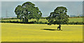
Oilseed rape, Lambeg - July 2018(2)
See Image Late-flowering oilseed rape in a field between Queensway and the McKinstry Road.
Image: © Albert Bridge
Taken: 7 Jul 2018
0.13 miles
2
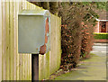
Drop box, Lambeg (2)
A drop box at the Moss Road end of Woodland Drive.
Image: © Albert Bridge
Taken: 21 Feb 2014
0.15 miles
3
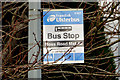
Bus stop, Moss Road, Lambeg
An Ulsterbus stop, on the outward side of Carrisbrook (correct spelling) Gardens, with the name “Moss Road Middle”. The other stops on the road seem to have the name of the nearest side road (save for the one at the Moss Road shops). Served by this Image
Image: © Albert Bridge
Taken: 21 Feb 2014
0.16 miles
4
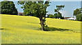
Oilseed rape, Lambeg - July 2018(1)
Late-flowering oilseed rape in a field between Queensway and the McKinstry Road. See also Image
Image: © Albert Bridge
Taken: 7 Jul 2018
0.18 miles
5
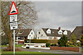
"Road humps" sign, Lisburn
A sign warning drivers, emerging from Sharry Drive and Cloverdale Crescent Image, about humps along the Moss Road.
Image: © Albert Bridge
Taken: 21 Feb 2014
0.19 miles
6
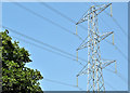
Pylon and power lines, Lambeg (July 2018)
See Image (July 2009). The same pylon, almost nine years later, seen from the McKinstry Road.
Image: © Albert Bridge
Taken: 7 Jul 2018
0.21 miles
7
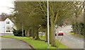
Cloverdale Crescent, Lisburn (1)
A development, mainly of chalet bungalows, running from the Moss Road (behind me) through to the Belsize Road. Chalet bungalows were popular in the 1960’s and early 1970’s but don’t seem to feature in 21st century schemes. Image shows the part which runs parallel to the Belsize Road.
Image: © Albert Bridge
Taken: 21 Feb 2014
0.22 miles
8
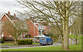
The Moss Road, Lisburn
The Moss Road runs, north west, from Queensway, Lambeg to the Belsize Road (behind me). The 1976 one-inch map shows that most of it had already been built. Part of Braemar Crescent is on the left.
Image: © Albert Bridge
Taken: 21 Feb 2014
0.22 miles
9

Pylon and power lines near Lambeg
Pylon and power lines across Queensway between Lambeg and Derriaghy – seen from Bell’s Lane Park. The continuation of the grid from Image
Image: © Albert Bridge
Taken: 20 Jul 2009
0.23 miles
10
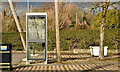
Telephone box, Lambeg (2)
A BT KX100 telephone box, outside the Moss Road shops, close to Woodland Park.
Image: © Albert Bridge
Taken: 21 Feb 2014
0.24 miles