IMAGES TAKEN NEAR TO
Oakridge Avenue, LISBURN, BT27 4NA
Introduction
This page details the photographs taken nearby to Oakridge Avenue, BT27 4NA by members of the Geograph project.
The Geograph project started in 2005 with the aim of publishing, organising and preserving representative images for every square kilometre of Great Britain, Ireland and the Isle of Man.

There are currently over 7.5m images from over14,400 individuals and you can help contribute to the project by visiting https://www.geograph.org.uk
Image Map
Images are licensed for reuse under creativecommons.org/licenses/by-sa/2.0
Notes
- Clicking on the map will re-center to the selected point.
- The higher the marker number, the further away the image location is from the centre of the postcode.
Image Listing (5 Images Found)
Images are licensed for reuse under creativecommons.org/licenses/by-sa/2.0
Image
Details
Distance
1
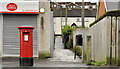
Pillar box, Lambeg
EIIR pillar box outside Moss Road post office, close to Woodland Park. The Post office is not quite at the place shown on the Google map.
Image: © Albert Bridge
Taken: 4 Dec 2011
0.15 miles
2
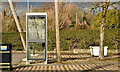
Telephone box, Lambeg (2)
A BT KX100 telephone box, outside the Moss Road shops, close to Woodland Park.
Image: © Albert Bridge
Taken: 21 Feb 2014
0.15 miles
3
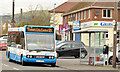
Minibus, Lambeg
An Ulsterbus Optare Solo (1873 DEZ 8873), on the Lisburn City Service 325A (Milltown Estate), calling at the Moss Road shops stop.
Image: © Albert Bridge
Taken: 21 Feb 2014
0.15 miles
4
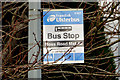
Bus stop, Moss Road, Lambeg
An Ulsterbus stop, on the outward side of Carrisbrook (correct spelling) Gardens, with the name “Moss Road Middle”. The other stops on the road seem to have the name of the nearest side road (save for the one at the Moss Road shops). Served by this Image
Image: © Albert Bridge
Taken: 21 Feb 2014
0.23 miles
5
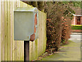
Drop box, Lambeg (2)
A drop box at the Moss Road end of Woodland Drive.
Image: © Albert Bridge
Taken: 21 Feb 2014
0.25 miles