IMAGES TAKEN NEAR TO
Fairfield, LISBURN, BT27 4EE
Introduction
This page details the photographs taken nearby to Fairfield, BT27 4EE by members of the Geograph project.
The Geograph project started in 2005 with the aim of publishing, organising and preserving representative images for every square kilometre of Great Britain, Ireland and the Isle of Man.

There are currently over 7.5m images from over14,400 individuals and you can help contribute to the project by visiting https://www.geograph.org.uk
Image Map
Images are licensed for reuse under creativecommons.org/licenses/by-sa/2.0
Notes
- Clicking on the map will re-center to the selected point.
- The higher the marker number, the further away the image location is from the centre of the postcode.
Image Listing (25 Images Found)
Images are licensed for reuse under creativecommons.org/licenses/by-sa/2.0
Image
Details
Distance
1
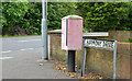
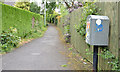
Drop box, Lambeg
A drop box at the Harmony Hill end of Harmony Drive.
Image: © Albert Bridge
Taken: 5 Jul 2013
0.06 miles
2
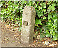
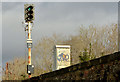
Old gas main marker post, Lisburn (1)
An old concrete post, on the eastern side of Harmony Hill, near Riverside Drive, marking the site of a town gas main. To the best of my knowledge Lisburn produced town gas from the late 1830’s to 1981. Image is a close look at the inscription.
Image: © Albert Bridge
Taken: 5 Jul 2013
0.08 miles
3
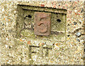
Old gas main marker post, Lisburn (2)
See Image A close look at the post showing how numbers could be inserted to show the appropriate distance to the main.
Image: © Albert Bridge
Taken: 5 Jul 2013
0.08 miles
4
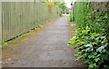
Lane, Lisburn
The Harmony Hill end of a lane from Richmond Court.
Image: © Albert Bridge
Taken: 5 Jul 2013
0.18 miles
5
Drop box, Lisburn
A drop box at the Harmony Hill end of this lane Image
Image: © Albert Bridge
Taken: 5 Jul 2013
0.18 miles
6
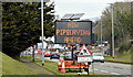
Mobile road sign, Hilden/Lambeg (March 2016)
A mobile road sign, powered by a solar panel, warning of pipe laying at Queensway, Lambeg. Part of the road, between the Lambeg Road traffic lights and Bell’s Lane, is currently coned into two narrow lanes.
Image: © Albert Bridge
Taken: 19 Mar 2016
0.22 miles
7

Lambeg drum poster, Lambeg/Hilden (March 2016)
A poster, at Queensway between Lambeg and Hilden, referring to the Lambeg drum https://en.wikipedia.org/wiki/Lambeg_drum. Commonly associated with the loyal orders, they can also be heard at drumming matches and Ulster Scots cultural events https://www.youtube.com/watch?v=xWEMraaauy0. See also Image
This photograph appears as neutral matter of record only. I cannot enter into correspondence.
Image: © Albert Bridge
Taken: 19 Mar 2016
0.22 miles
8
Railway signal, Hilden/Lambeg
A three-aspect colour light signal (CL 141), beside the down line, between Hilden and Lambeg.
Image: © Albert Bridge
Taken: 21 Feb 2014
0.22 miles
9
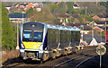
Train, Hilden (2012-2)
C4K set 4014, working the 10.15 Portadown – Bangor, after departing Hilden, heading towards a three-aspect colour light signal. This part of the line is known for its tight curves and restricted visibility. It’s also one of the places where, unless there was a major realignment or tilting stock, the speed limit cannot be raised to 90mph. The satellite photograph (at the time of submission) shows a train at the down platform
Image: © Albert Bridge
Taken: 1 Dec 2012
0.22 miles
10
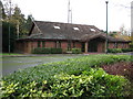
Church of Jesus Christ of Latter Day Saints
On Belsize Road, Lisburn.
Image: © Brian Shaw
Taken: 16 Nov 2005
0.23 miles