IMAGES TAKEN NEAR TO
Llewellyn Drive, LISBURN, BT27 4AQ
Introduction
This page details the photographs taken nearby to Llewellyn Drive, BT27 4AQ by members of the Geograph project.
The Geograph project started in 2005 with the aim of publishing, organising and preserving representative images for every square kilometre of Great Britain, Ireland and the Isle of Man.

There are currently over 7.5m images from over14,400 individuals and you can help contribute to the project by visiting https://www.geograph.org.uk
Image Map
Images are licensed for reuse under creativecommons.org/licenses/by-sa/2.0
Notes
- Clicking on the map will re-center to the selected point.
- The higher the marker number, the further away the image location is from the centre of the postcode.
Image Listing (59 Images Found)
Images are licensed for reuse under creativecommons.org/licenses/by-sa/2.0
Image
Details
Distance
1
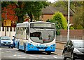
Sprucefield bus, Lisburn
The 13.45 Belfast (Upper Queen Street) – Sprucefield Shopping Centre at the Belfast Road roundabout. This is an infrequent service.
Image: © Albert Bridge
Taken: 2 Oct 2009
0.05 miles
2
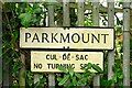
Street sign, Lisburn
Another one of those signs that, come next summer, could be hidden by vegetation.
Image: © Albert Bridge
Taken: 11 Jan 2009
0.06 miles
3
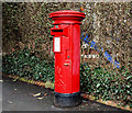
Pillar box, Lisburn
EIIR pillar box at the Seymour Street end of Llewellyn Avenue (shown as Seymour Street on the Google map).
Image: © Albert Bridge
Taken: 2 Jan 2011
0.06 miles
5
Seymour Street, Lisburn
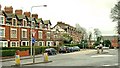
The approach to Lisburn from the Belfast direction. The Belfast Road is on this side of the mini-roundabout. The attractive houses of Llewellyn Drive and Avenue (shown as Seymour Street on the Google map) are on the left. See also Image
Image: © Albert Bridge
Taken: 11 Jan 2009
0.07 miles
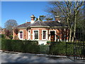
6
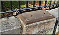
Park railings, Lisburn
The railings at the Seymour Street end of the Wallace Park. The stubs look like a case of the originals being removed for melting during WWII. Unlike here Image they have been replaced.
Image: © Albert Bridge
Taken: 12 Sep 2010
0.08 miles
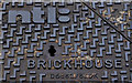
7
NTL access cover, Lisburn (1)
NTL provided a telephone, cable television and internet service – part of Virgin Media since 2006. This Brickhouse cover is on the Belfast Road, opposite Garvey Manor. Image shows the logo and foundry name.
Image: © Albert Bridge
Taken: 13 Jul 2011
0.08 miles
8
NTL access cover, Lisburn (2)
See Image The NTL logo and the foundry name.
Image: © Albert Bridge
Taken: 13 Jul 2011
0.08 miles
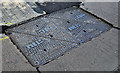
9
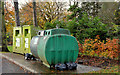
Recycling bins, Lisburn
Recycling bins at the north eastern end of the Wallace Park.
Image: © Albert Bridge
Taken: 5 Nov 2012
0.08 miles
10
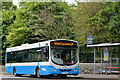
Belfast bus, Lisburn
An Ulsterbus Wrightbus-bodied Scania (469 BFZ 8469) calling at the Wallace Park stop (officially “Park Gates”) with the 11.10 Laurelhill – Belfast, Donegall Square North – quite a long run of 55 minutes.
Image: © Albert Bridge
Taken: 15 Jul 2013
0.09 miles