IMAGES TAKEN NEAR TO
Pantridge Lane, HILLSBOROUGH, BT26 6TP
Introduction
This page details the photographs taken nearby to Pantridge Lane, BT26 6TP by members of the Geograph project.
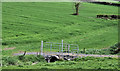
The Geograph project started in 2005 with the aim of publishing, organising and preserving representative images for every square kilometre of Great Britain, Ireland and the Isle of Man.

There are currently over 7.5m images from over14,400 individuals and you can help contribute to the project by visiting https://www.geograph.org.uk
Image Map
Images are licensed for reuse under creativecommons.org/licenses/by-sa/2.0
Notes
- Clicking on the map will re-center to the selected point.
- The higher the marker number, the further away the image location is from the centre of the postcode.
Image Listing (40 Images Found)
Images are licensed for reuse under creativecommons.org/licenses/by-sa/2.0
Image
Details
Distance
1
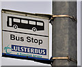
Bus stop sign, Hillsborough
See Image The modern sign which replaced the concrete one.
Image: © Albert Bridge
Taken: 24 Apr 2011
0.04 miles
2
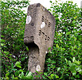
Concrete bus stop sign, Hillsborough (2)
A concrete bus stop sign on the Dromore Road (inward) near the site of the former Monument petrol station. Unlike this one Image, where the sign is still in use, it has been replaced by the current version Image
Image: © Albert Bridge
Taken: 24 Apr 2011
0.04 miles
3
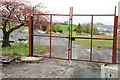
Former "White Gables" hotel, Hillsborough
The “White Gables” opened in the mid-70’s at a time when hotels were a scarce commodity in NI and when overnight visitors were reluctant to stay in Belfast. Now closed and demolished but still mentioned on some accommodation websites. My understanding is that the intention was to build houses here but the site (between the Dromore Road and the bypass Image) was not zoned for housing.
Image: © Albert Bridge
Taken: 5 May 2010
0.05 miles
4
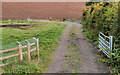
Track, Hillsborough
A track, leading from the Dromore Road, to the fields on the eastern side of the Hillsborough bypass.
Image: © Albert Bridge
Taken: 2 Oct 2010
0.10 miles
5
Culvert, Hillsborough
Farm track and culvert across the watercourse, near the Dromore Road, seen in Image
Image: © Albert Bridge
Taken: 24 Apr 2011
0.11 miles
6
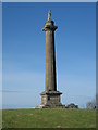
Monument
This monumental pillar commemorates Arthur Hill, Third Marquis of Downshire (1788-1845). He died at his estates at Blessington, Co, Wicklow and it is said that his funeral was the longest in Ireland.
Image: © Brian Shaw
Taken: 9 Nov 2005
0.13 miles
7
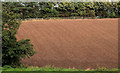
Field, Hillsborough (2)
Part of a recently-ploughed field between the Dromore Road and the bypass.
Image: © Albert Bridge
Taken: 2 Oct 2010
0.15 miles
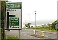
8
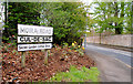
Moira Road sign, Hillsborough
The unclassified Hillsborough – Moira road crossed the bypass Image “at grade” ie on the level. The scene of several accidents, it was eventually stopped up (on the eastern side of the bypass) and is now a cul-de-sac. The flyover Image, on the Dromore Road, has simplified matters.
Image: © Albert Bridge
Taken: 5 May 2010
0.16 miles
9
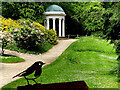
Lady Alice's Temple, Hillsborough Castle Grounds
It is constructed out of cast iron
Image: © Kenneth Allen
Taken: 17 May 2023
0.17 miles
10
Flyover, Hillsborough (6)
See Image Three for the price of one on the Dromore Road. An advance direction sign, a traffic island and the flyover (lower right).
Image: © Albert Bridge
Taken: 2 Oct 2009
0.17 miles