IMAGES TAKEN NEAR TO
Larchfield Gate, HILLSBOROUGH, BT26 6SN
Introduction
This page details the photographs taken nearby to Larchfield Gate, BT26 6SN by members of the Geograph project.
The Geograph project started in 2005 with the aim of publishing, organising and preserving representative images for every square kilometre of Great Britain, Ireland and the Isle of Man.

There are currently over 7.5m images from over14,400 individuals and you can help contribute to the project by visiting https://www.geograph.org.uk
Image Map
Images are licensed for reuse under creativecommons.org/licenses/by-sa/2.0
Notes
- Clicking on the map will re-center to the selected point.
- The higher the marker number, the further away the image location is from the centre of the postcode.
Image Listing (2 Images Found)
Images are licensed for reuse under creativecommons.org/licenses/by-sa/2.0
Image
Details
Distance
1
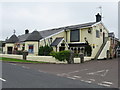
The 'Pheasant', near Annahilt
Comfortable pub and restaurant with excellent food
Image: © Dr Neil Clifton
Taken: 28 Jun 2009
0.14 miles
2
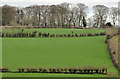
Fields near Annahilt
Medium-sized fields, on the side of a drumlin (standard for this part of Co Down) seen from beside the Church of the Ascension Image
Image: © Albert Bridge
Taken: 19 Mar 2012
0.23 miles