IMAGES TAKEN NEAR TO
Magheraconluce Road, HILLSBOROUGH, BT26 6QH
Introduction
This page details the photographs taken nearby to Magheraconluce Road, BT26 6QH by members of the Geograph project.
The Geograph project started in 2005 with the aim of publishing, organising and preserving representative images for every square kilometre of Great Britain, Ireland and the Isle of Man.

There are currently over 7.5m images from over14,400 individuals and you can help contribute to the project by visiting https://www.geograph.org.uk
Image Map
Images are licensed for reuse under creativecommons.org/licenses/by-sa/2.0
Notes
- Clicking on the map will re-center to the selected point.
- The higher the marker number, the further away the image location is from the centre of the postcode.
Image Listing (4 Images Found)
Images are licensed for reuse under creativecommons.org/licenses/by-sa/2.0
Image
Details
Distance
1
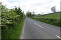
Magheraconluce Road
Looking south-west.
Image: © Robert Ashby
Taken: 10 Jun 2015
0.12 miles
2
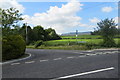
Road Junction
Where Rafferty's Hill meets Magheraconluce Road.
Image: © Robert Ashby
Taken: 10 Jun 2015
0.12 miles
3
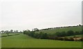
Undulating pasture land on the south side of Magheraconluce Road
Image: © Eric Jones
Taken: 31 Oct 2015
0.12 miles
4
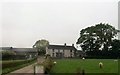
Farm house at Lakeside View Caravan Park
The caravan site overlooks Lough Aghery
Image: © Eric Jones
Taken: 31 Oct 2015
0.14 miles