IMAGES TAKEN NEAR TO
McKees Bridge Road, HILLSBOROUGH, BT26 6PF
Introduction
This page details the photographs taken nearby to McKees Bridge Road, BT26 6PF by members of the Geograph project.
The Geograph project started in 2005 with the aim of publishing, organising and preserving representative images for every square kilometre of Great Britain, Ireland and the Isle of Man.

There are currently over 7.5m images from over14,400 individuals and you can help contribute to the project by visiting https://www.geograph.org.uk
Image Map
Images are licensed for reuse under creativecommons.org/licenses/by-sa/2.0
Notes
- Clicking on the map will re-center to the selected point.
- The higher the marker number, the further away the image location is from the centre of the postcode.
Image Listing (6 Images Found)
Images are licensed for reuse under creativecommons.org/licenses/by-sa/2.0
Image
Details
Distance
1
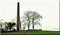
Old chimney, Aghandunvarran near Hillsborough
See Image (November 2005). The same chimney, between the McKee’s Bridge Road (behind the hedge and trees on the left) and the Dromara Road (behind me). Despite much “Googling” and checking in definitive books including “The Town in Ulster”, “The Industrial Archaeology of Northern Ireland” and the Ordnance Survey Memoirs I have not been able to discover anything about the origin of the structure. It is, however, in the square immediately east of McKee’s Dam Image so it might be reasonable to guess that the two were not unconnected.
I have found a list of flax growers in Co Down (1796) which shows that there were 24 with an address of “Hillsborough”.
Not listed and not on the official “at risk register”.
Further information very welcome.
Image: © Albert Bridge
Taken: 23 Dec 2012
0.17 miles
2

Wild poppies near Hillsborough
Wild poppies would not be the most common of wildflowers in Co Down. These specimens were growing in recently turned soil in the lay-by at McKee’s Dam Image
Image: © Albert Bridge
Taken: 26 Jun 2010
0.19 miles
3
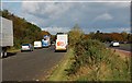
Lay-by near Hillsborough
The lay-by at McKee’s Dam was created when the road was realigned and dualled in the 70’s. The main road Image is on the right. McKee’s Dam (a disused flax-retting dam) is behind the trees on the left. It is a popular spot around lunchtime and features a sizeable chip van. The view is towards Belfast.
Image: © Albert Bridge
Taken: 17 Oct 2007
0.22 miles
4
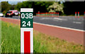
Roadside post near Hillsborough
Roads Service post, beside the northbound carriageway, immediately south of Image
Image: © Albert Bridge
Taken: 31 May 2010
0.22 miles
5
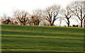
Winter trees near Hillsborough
Winter trees, in a field between the old Dromore Road and the Dromara Road (behind me), to the north of Image
Image: © Albert Bridge
Taken: 23 Dec 2012
0.25 miles
6
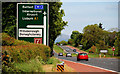
Advance direction sign near Hillsborough
Advance direction sign (northbound) for the flyover Image on the Dromore Road, Hillsborough.
Image: © Albert Bridge
Taken: 31 May 2010
0.25 miles