IMAGES TAKEN NEAR TO
HILLSBOROUGH, BT26 6JU
Introduction
This page details the photographs taken nearby to BT26 6JU by members of the Geograph project.
The Geograph project started in 2005 with the aim of publishing, organising and preserving representative images for every square kilometre of Great Britain, Ireland and the Isle of Man.

There are currently over 7.5m images from over14,400 individuals and you can help contribute to the project by visiting https://www.geograph.org.uk
Image Map
Images are licensed for reuse under creativecommons.org/licenses/by-sa/2.0
Notes
- Clicking on the map will re-center to the selected point.
- The higher the marker number, the further away the image location is from the centre of the postcode.
Image Listing (4 Images Found)
Images are licensed for reuse under creativecommons.org/licenses/by-sa/2.0
Image
Details
Distance
1

House on the Hill
Beside the old Dromore Road out of Hillsborough.
Image: © Brian Shaw
Taken: 21 Dec 2005
0.10 miles
2
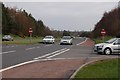
The Dromore Road, Hillsborough
When the Belfast-Dublin road near Hillsborough was dualled in the early 70’s the Dromore Road, Hillsborough was reclassified as a “B” road. It still serves local houses and joins the dual carriageway by an “at grade” junction. There are plans to reduce the number of such junctions by the construction of flyovers. The view is towards Belfast with the Dromore Road on the right. Continue to Image
Image: © Albert Bridge
Taken: 17 Mar 2007
0.10 miles
3
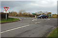
The Dromore Road, Hillsborough (2)
See Image The car is making a “U” turn – a manoeuvre which is allowed but is not always easy. The view is from the (old) Dromore Road.
Image: © Albert Bridge
Taken: 17 Mar 2007
0.10 miles
4
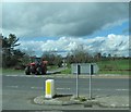
Tractor about to join the A1 from Taughblane Road
Image: © Eric Jones
Taken: 2 Apr 2011
0.11 miles