IMAGES TAKEN NEAR TO
Aghnatrisk Road, HILLSBOROUGH, BT26 6JJ
Introduction
This page details the photographs taken nearby to Aghnatrisk Road, BT26 6JJ by members of the Geograph project.
The Geograph project started in 2005 with the aim of publishing, organising and preserving representative images for every square kilometre of Great Britain, Ireland and the Isle of Man.

There are currently over 7.5m images from over14,400 individuals and you can help contribute to the project by visiting https://www.geograph.org.uk
Image Map
Images are licensed for reuse under creativecommons.org/licenses/by-sa/2.0
Notes
- Clicking on the map will re-center to the selected point.
- The higher the marker number, the further away the image location is from the centre of the postcode.
Image Listing (3 Images Found)
Images are licensed for reuse under creativecommons.org/licenses/by-sa/2.0
Image
Details
Distance
1
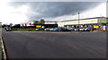
Industrial estate
Small industrial estate on the Aghnatrisk Road near Hillsborough.
Image: © Robert Ashby
Taken: 29 Apr 2015
0.18 miles
3
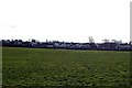
A Concrete Jungle
A Concrete Jungle of new houses built within the last couple of years at Culcavey, near Hillsborough. The GNRI railway line (disused) ran on a high embankment to the left of the photo.
Image: © Wilson Adams
Taken: 18 Feb 2007
0.19 miles