IMAGES TAKEN NEAR TO
Grove Park, HILLSBOROUGH, BT26 6JF
Introduction
This page details the photographs taken nearby to Grove Park, BT26 6JF by members of the Geograph project.
The Geograph project started in 2005 with the aim of publishing, organising and preserving representative images for every square kilometre of Great Britain, Ireland and the Isle of Man.

There are currently over 7.5m images from over14,400 individuals and you can help contribute to the project by visiting https://www.geograph.org.uk
Image Map
Images are licensed for reuse under creativecommons.org/licenses/by-sa/2.0
Notes
- Clicking on the map will re-center to the selected point.
- The higher the marker number, the further away the image location is from the centre of the postcode.
Image Listing (14 Images Found)
Images are licensed for reuse under creativecommons.org/licenses/by-sa/2.0
Image
Details
Distance
1
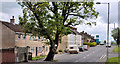
The Culcavy Road, Culcavy
The Culcavy Road, Culcavy looking towards Newport, just past the site of the former mill. The row on the left is Ogle Terrace. Ogle is a common surname in this part of Co Down.
Image: © Albert Bridge
Taken: 8 Jun 2011
0.07 miles
2
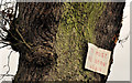
Biblical message, Culcavy
On the Culcavy Road, one of two attached to the tree on the left in Image
Image: © Albert Bridge
Taken: 24 Dec 2011
0.09 miles
3

Culcavy mill (site of), Culcavy (1)
A housing development called “The Old Mill” now occupies the site of the former Hillsborough Linen Company. The business seems to have traded from 1866 to 1966 initially as the Hillsborough Woollen Company before changing its name in 1871. The mill pond survives, albeit as private property, and is visible from the main road. See also Image
Image: © Albert Bridge
Taken: 8 Jun 2011
0.09 miles
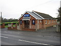
4
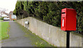
Letter box, Culcavy, Hillsborough
Post-mounted EIIR letter box, at Coachman’s Way on the Culcavy Road.
Image: © Albert Bridge
Taken: 24 Dec 2011
0.09 miles
5

Culcavy mill (site of), Culcavy (2)
The mill has gone but is remembered in the name of this housing development Image (shown as Theodore Street on the large-scale Google map).
Image: © Albert Bridge
Taken: 8 Jun 2011
0.10 miles
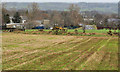
6
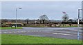
Crossroads, Culcavy
A crossroads at the northern end of Culcavy. The Culcavy Road (Hillsborough-Newport) runs from left to right. Harry’s Road (to Carnbane) is on the right. The Aghnatrisk Road runs towards that townland (second left). The crossroads marks the de-facto limit of most residential (but not commercial) development.
Image: © Albert Bridge
Taken: 24 Dec 2011
0.10 miles
7
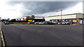
Industrial estate
Small industrial estate on the Aghnatrisk Road near Hillsborough.
Image: © Robert Ashby
Taken: 29 Apr 2015
0.15 miles
9
A Concrete Jungle
A Concrete Jungle of new houses built within the last couple of years at Culcavey, near Hillsborough. The GNRI railway line (disused) ran on a high embankment to the left of the photo.
Image: © Wilson Adams
Taken: 18 Feb 2007
0.16 miles
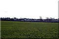
10
Field near Culcavy
Image: © Albert Bridge
Taken: 24 Dec 2011
0.17 miles