IMAGES TAKEN NEAR TO
Farriers Green, HILLSBOROUGH, BT26 6GW
Introduction
This page details the photographs taken nearby to Farriers Green, BT26 6GW by members of the Geograph project.
The Geograph project started in 2005 with the aim of publishing, organising and preserving representative images for every square kilometre of Great Britain, Ireland and the Isle of Man.

There are currently over 7.5m images from over14,400 individuals and you can help contribute to the project by visiting https://www.geograph.org.uk
Image Map
Images are licensed for reuse under creativecommons.org/licenses/by-sa/2.0
Notes
- Clicking on the map will re-center to the selected point.
- The higher the marker number, the further away the image location is from the centre of the postcode.
Image Listing (2 Images Found)
Images are licensed for reuse under creativecommons.org/licenses/by-sa/2.0
Image
Details
Distance
1
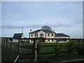
Oaklands Lodge
Currently on the market at £895,000.
Image: © Brian Shaw
Taken: 21 Dec 2005
0.15 miles
2
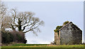
Old building near Hillsborough
An old and semi-derelict building (which doesn’t seem to have been a cottage) beside the Comber Road, at Carnreagh.
Image: © Albert Bridge
Taken: 30 Dec 2012
0.19 miles