IMAGES TAKEN NEAR TO
Governors Gate Meadow, HILLSBOROUGH, BT26 6FY
Introduction
This page details the photographs taken nearby to Governors Gate Meadow, BT26 6FY by members of the Geograph project.
The Geograph project started in 2005 with the aim of publishing, organising and preserving representative images for every square kilometre of Great Britain, Ireland and the Isle of Man.

There are currently over 7.5m images from over14,400 individuals and you can help contribute to the project by visiting https://www.geograph.org.uk
Image Map
Images are licensed for reuse under creativecommons.org/licenses/by-sa/2.0
Notes
- Clicking on the map will re-center to the selected point.
- The higher the marker number, the further away the image location is from the centre of the postcode.
Image Listing (23 Images Found)
Images are licensed for reuse under creativecommons.org/licenses/by-sa/2.0
Image
Details
Distance
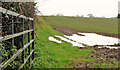
1
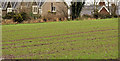
Field, Hillsborough (8)
The northern side of this field Image, beside the Ballynahinch Road Image, showing part of Governor’s Gate Image and the end of developed Hillsborough.
Image: © Albert Bridge
Taken: 8 Jan 2012
0.15 miles
2
Field, Hillsborough (9)
The northern end of a field on the north eastern side of the Ballynahinch Road Image
Image: © Albert Bridge
Taken: 11 Feb 2012
0.15 miles
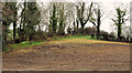
3
Field, Hillsborough (7)
Part of the first field (immediately before this one Image) on the Ballynahinch Road Image, after the end of developed Hillsborough, at Governor’s Gate Image
Image: © Albert Bridge
Taken: 8 Jan 2012
0.17 miles
4
Governors Gate Estate, off the Ballynahinch Road
This a new estate of executive housing.
Image: © Eric Jones
Taken: 12 Oct 2012
0.18 miles
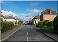
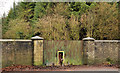
5
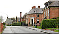
Governor's Gate, Hillsborough
Governor’s Gate is the next and last development after Kilwarlin Way Image, on the Ballynahinch Road Image Most of the houses are built in a traditional style albeit not always in the local vernacular. See also Image
Image: © Albert Bridge
Taken: 8 Jan 2012
0.18 miles
6

Foxgloves, Hillsborough forest
A late foxglove growing between the conifers and one of the paths.
Image: © Albert Bridge
Taken: 25 Sep 2009
0.19 miles
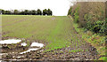
7
Field, Hillsborough (6)
The entrance to a field, on the eastern side of the Ballynahinch Road Image, just beyond the end of developed Hillsborough.
Image: © Albert Bridge
Taken: 8 Jan 2012
0.19 miles
8
The old Comber Road, Hillsborough (2)
See Image The other end of the old road. The present alignment is in the foreground. The stopped-up end is out of picture to the right.
Image: © Albert Bridge
Taken: 11 Feb 2012
0.20 miles
9
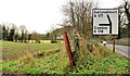
Advance direction sign, Hillsborough
An advance direction sign, beside this field Image, on the Ballynahinch Road Image, before the Comber Road Image Road numbering in NI does not follow any logical system. Two sequentially-numbered roads like this are not common Image
Image: © Albert Bridge
Taken: 8 Jan 2012
0.20 miles
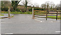
10
Forest gate, Hillsborough
A frequently-used pedestrian gate (a bit smaller than average) leading into Hillsborough forest, set into a (possibly disused) vehicular gate in this wall Image along the Ballynahinch Road Image
Image: © Albert Bridge
Taken: 8 Jan 2012
0.21 miles