IMAGES TAKEN NEAR TO
Ballygowan Road, HILLSBOROUGH, BT26 6EJ
Introduction
This page details the photographs taken nearby to Ballygowan Road, BT26 6EJ by members of the Geograph project.
The Geograph project started in 2005 with the aim of publishing, organising and preserving representative images for every square kilometre of Great Britain, Ireland and the Isle of Man.

There are currently over 7.5m images from over14,400 individuals and you can help contribute to the project by visiting https://www.geograph.org.uk
Image Map
Images are licensed for reuse under creativecommons.org/licenses/by-sa/2.0
Notes
- Clicking on the map will re-center to the selected point.
- The higher the marker number, the further away the image location is from the centre of the postcode.
Image Listing (2 Images Found)
Images are licensed for reuse under creativecommons.org/licenses/by-sa/2.0
Image
Details
Distance
1
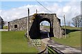
Railway Arch
A short railway arch on an unidentified road/laneway near the Ballygowan Rd, Hillsborough.
An embankment stood on both sides of the arch carrying the railway from Hillsborough to Banbridge, across the road/laneway. However, the owners of the land decided to remove the embankment and return the land to what it may have looked liked before the railway was built in 1863.
Image: © Wilson Adams
Taken: 3 Mar 2007
0.23 miles
2
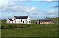
A New House?
It could be a newly built house, or an existing one converted, (not sure). But, the stone built double garage to the right of the house, never existed.
The garage was built after the owners of the land removed the railway embankment. The image was made from the Ballygowan Rd in (grid J2158).
Image: © Wilson Adams
Taken: 3 Mar 2007
0.23 miles