IMAGES TAKEN NEAR TO
Ballygowan Road, HILLSBOROUGH, BT26 6EG
Introduction
This page details the photographs taken nearby to Ballygowan Road, BT26 6EG by members of the Geograph project.
The Geograph project started in 2005 with the aim of publishing, organising and preserving representative images for every square kilometre of Great Britain, Ireland and the Isle of Man.

There are currently over 7.5m images from over14,400 individuals and you can help contribute to the project by visiting https://www.geograph.org.uk
Image Map
Images are licensed for reuse under creativecommons.org/licenses/by-sa/2.0
Notes
- Clicking on the map will re-center to the selected point.
- The higher the marker number, the further away the image location is from the centre of the postcode.
Image Listing (3 Images Found)
Images are licensed for reuse under creativecommons.org/licenses/by-sa/2.0
Image
Details
Distance
1
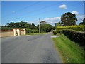
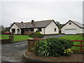
Ballygowan Road, Hillsborough
This busy minor route serves the many large dwellings that have helped extend Belfast's commuter belt to this quiet end of the country.
Image: © Dean Molyneaux
Taken: 15 Aug 2010
0.22 miles
2
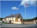
Ballygowan Orange Hall (2010)
This well-kept hall is situated along the Ballygowan Road in the townland of that name. It is home to Ballygowan Loyal Orange Lodge No. 422 and Royal Black Preceptory No. 172 ("Ballygowan Rose of Truth"). It was constructed in 1899.
Image: © Dean Molyneaux
Taken: 15 Aug 2010
0.24 miles