IMAGES TAKEN NEAR TO
Burn Road, HILLSBOROUGH, BT26 6BZ
Introduction
This page details the photographs taken nearby to Burn Road, BT26 6BZ by members of the Geograph project.
The Geograph project started in 2005 with the aim of publishing, organising and preserving representative images for every square kilometre of Great Britain, Ireland and the Isle of Man.

There are currently over 7.5m images from over14,400 individuals and you can help contribute to the project by visiting https://www.geograph.org.uk
Image Map
Images are licensed for reuse under creativecommons.org/licenses/by-sa/2.0
Notes
- Clicking on the map will re-center to the selected point.
- The higher the marker number, the further away the image location is from the centre of the postcode.
Image Listing (4 Images Found)
Images are licensed for reuse under creativecommons.org/licenses/by-sa/2.0
Image
Details
Distance
1
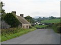
Old cottage by the roadside
Looking down Burn Road with a view of the mountains in the distance.
Image: © Ian Paterson
Taken: 21 Sep 2010
0.02 miles
2
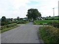
Country crossroads
View southwards near the junction of Burn Road and Cargygray Road.
Image: © Ian Paterson
Taken: 21 Sep 2010
0.15 miles
3
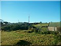
Farm buildings south of the Ballynahinch Road
Image: © Eric Jones
Taken: 12 Oct 2012
0.20 miles
4
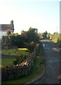
Burn Road at its junction with Ballynahinch Road
Image: © Eric Jones
Taken: 12 Oct 2012
0.22 miles