IMAGES TAKEN NEAR TO
Dunbeg Park, HILLSBOROUGH, BT26 6AS
Introduction
This page details the photographs taken nearby to Dunbeg Park, BT26 6AS by members of the Geograph project.
The Geograph project started in 2005 with the aim of publishing, organising and preserving representative images for every square kilometre of Great Britain, Ireland and the Isle of Man.

There are currently over 7.5m images from over14,400 individuals and you can help contribute to the project by visiting https://www.geograph.org.uk
Image Map
Images are licensed for reuse under creativecommons.org/licenses/by-sa/2.0
Notes
- Clicking on the map will re-center to the selected point.
- The higher the marker number, the further away the image location is from the centre of the postcode.
Image Listing (78 Images Found)
Images are licensed for reuse under creativecommons.org/licenses/by-sa/2.0
Image
Details
Distance
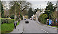
1
Attractive retro-style housing on the corner of Carnreagh and Ballynahinch Roads
Image: © Eric Jones
Taken: 5 Apr 2011
0.05 miles
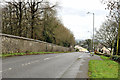
3
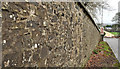
Forest wall, Hillsborough (1)
Part of the long boundary wall between Hillsborough forest and the Ballynahinch Road. This section is at the northern end of the forest, on the drop down to Ballynahinch Street and the Carnreagh Road Image (background).
Image: © Albert Bridge
Taken: 8 Jan 2012
0.07 miles
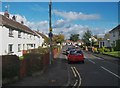
4
The Carnreagh Road, Hillsborough
A minor road, running north from the Ballynahinch Road, through the drumlins, near Hillsborough.
Image: © Albert Bridge
Taken: 8 Jun 2011
0.07 miles
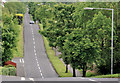
5
The Ballynahinch Road, Hillsborough (1)
The Hillsborough end of the road, through the Co Down drumlins, from Ballynahinch. This forest wall Image is on the left.
Image: © Albert Bridge
Taken: 8 Jan 2012
0.07 miles
6
The junction of Carnreagh and Ballynahinch roads on the outskirts of Hillsborough
Image: © Eric Jones
Taken: 12 Oct 2012
0.08 miles
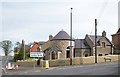
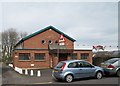
7
Downshire Primary School, Hillsborough
This school stands in Ballynahinch Road
Image: © Eric Jones
Taken: 6 Apr 2011
0.11 miles
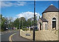
8
The Orange Hall, Hillsborough
This has been the home of LOL 288 (established 1798) since 1958. LOL stands for Loyal Orange Lodge.
Image: © Eric Jones
Taken: 5 Apr 2011
0.11 miles
9
Ballynahinch Street, Hillsborough
A mixed commercial and residential street running from Main Street (background) to the Carnreagh Image and Ballynahinch Roads. Shown as Ballynahinch Road on the Google map.
Image: © Albert Bridge
Taken: 8 Jan 2012
0.13 miles
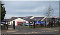
10
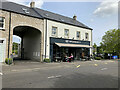
Owl & Pussycat cafe, Royal Hillsborough
Pictured along Ballynahinch Road
Image: © Kenneth Allen
Taken: 17 May 2023
0.13 miles