1
Ulsterbus "Goldline" express, Saintfield
An Ulsterbus Irizar-bodied Scania (1077 LFZ 9077) running out the Crossgar Road with 10.00 Belfast Laganside Buscentre – Downpatrick “Goldline” express.
Image: © Albert Bridge
Taken: 31 Mar 2014
0.07 miles
2
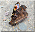
Peacock butterfly, Saintfield
A peacock butterfly http://www.geograph.org.uk/search.php?i=43428066 on the footpath, on the Crossgar Road, beside the bowling green. It seemed to be barely alive.
Image: © Albert Bridge
Taken: 26 Aug 2013
0.08 miles
3
Roof and solar panels, Saintfield
Solar panels on the south-facing roof of a house near the Crossgar Road. Subject position approximate.
Image: © Albert Bridge
Taken: 26 Aug 2013
0.11 miles
4
Bowling green, Saintfield
Saintfield Bowling Club’s green on the Crossgar Road. The club plays in the Private Greens League.
Image: © Albert Bridge
Taken: 14 Nov 2009
0.13 miles
5
Queen's Park, Saintfield
The Crossgar Road end of a small estate between it and Downpatrick Street.
Image: © Albert Bridge
Taken: 26 Aug 2013
0.13 miles
6
Roman Catholic church, Saintfield
Mary Mother of the Church Roman Catholic church, on the Crossgar Road, dates from 1890. It replaced a smaller building (still in existence) at Main Street. Last seen in
Image (October 2005).
Image: © Albert Bridge
Taken: 31 Mar 2014
0.14 miles
7
The Old Grand Jury Road, Saintfield (1)
The Old Grand Jury Road runs from the Crossgar Road to Downpatrick Street and Main Street. It was once part of the main road from Downpatrick to Belfast (via the Old Belfast Road).
Grand Juries were part of the system of local Government in Ireland (roughly equivalent to county councils) and were – in later years - responsible for the provision and maintenance of what became known as “the county road”. They were abolished in 1898. See also
Image
Image: © Albert Bridge
Taken: 14 Nov 2009
0.14 miles
8
New social housing, Saintfield - October 2015(1)
The new housing association properties nearing completion, built on the old police station site, on the Crossgar Road – apartments on the left and houses in the background.
Image: © Albert Bridge
Taken: 17 Oct 2015
0.15 miles
9
Former police station, Saintfield - March 2014(4)
The skeletal roof after removal of the slates.
Image: © Albert Bridge
Taken: 31 Mar 2014
0.15 miles
10
Former police station, Saintfield - March 2014(3)
A chimney, at the Crossgar end of the building, with a capped pot partly enclosed by mesh.
Image: © Albert Bridge
Taken: 31 Mar 2014
0.15 miles


