
IMAGES TAKEN NEAR TO
Forge Hill Close, BALLYNAHINCH, BT24 7NJ
Introduction
This page details the photographs taken nearby to Forge Hill Close, BT24 7NJ by members of the Geograph project.
The Geograph project started in 2005 with the aim of publishing, organising and preserving representative images for every square kilometre of Great Britain, Ireland and the Isle of Man.

There are currently over 7.5m images from over14,400 individuals and you can help contribute to the project by visiting https://www.geograph.org.uk
Image Map
Images are licensed for reuse under creativecommons.org/licenses/by-sa/2.0
Notes
- Clicking on the map will re-center to the selected point.
- The higher the marker number, the further away the image location is from the centre of the postcode.
Image Listing (111 Images Found)
Images are licensed for reuse under creativecommons.org/licenses/by-sa/2.0
Image
Details
Distance
1
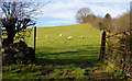
Sheep and field, Saintfield
Sheep grazing in a field, close to the town centre. An amazing survival given the number of new houses built in the town in recent years.
Image: © Albert Bridge
Taken: 14 Nov 2009
0.04 miles
2
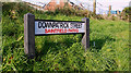
Street sign, Saintfield
Unusually for an urban area, this sign shows the townland (Saintfield Parks) as well as the street name.
Image: © Albert Bridge
Taken: 14 Nov 2009
0.06 miles
3
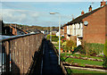
Downpatrick Street, Saintfield
With Saintfield being in the middle of Drumlin country, it’s not surprising that some houses are below the level of those on the other side of the street.
Image: © Albert Bridge
Taken: 14 Nov 2009
0.07 miles
4
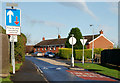
Traffic calming, Saintfield
Traffic-calming arrangements in Downpatrick Street/the Listooder Road. See also Image
Image: © Albert Bridge
Taken: 14 Nov 2009
0.09 miles
5
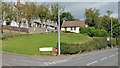
Queen's Park, Saintfield
The Crossgar Road end of a small estate between it and Downpatrick Street.
Image: © Albert Bridge
Taken: 26 Aug 2013
0.11 miles
6
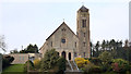
Roman Catholic church, Saintfield
Mary Mother of the Church Roman Catholic church, on the Crossgar Road, dates from 1890. It replaced a smaller building (still in existence) at Main Street. Last seen in Image (October 2005).
Image: © Albert Bridge
Taken: 31 Mar 2014
0.12 miles
7
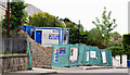
New social housing site, Saintfield (July 2014)
New social housing now under construction, on the Crossgar Road, on the site of the old police station.
Image: © Albert Bridge
Taken: 30 Jul 2014
0.12 miles
8
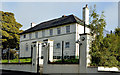
Former police station, Saintfield
The closed police station on the Crossgar Road. Another one by TPO Rippingham similar to that at Templepatrick Image Not quite original externally, the ground-floor windows have been altered.
Image: © Albert Bridge
Taken: 6 Oct 2012
0.12 miles
9

Public toilets, Saintfield
Self-cleaning public toilets on the northern side of the New Line. For many years this was the standard design used by Down District Council. Recent ones have been in a different style.
Image: © Albert Bridge
Taken: 13 Apr 2013
0.12 miles
10
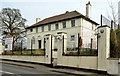
Former police station, Saintfield - March 2014(1)
The closed police station, from the Crossgar side, still standing but with all the slates removed.
Image: © Albert Bridge
Taken: 31 Mar 2014
0.13 miles