IMAGES TAKEN NEAR TO
Thornleigh Crescent, NEWTOWNARDS, BT23 8TL
Introduction
This page details the photographs taken nearby to Thornleigh Crescent, BT23 8TL by members of the Geograph project.
The Geograph project started in 2005 with the aim of publishing, organising and preserving representative images for every square kilometre of Great Britain, Ireland and the Isle of Man.

There are currently over 7.5m images from over14,400 individuals and you can help contribute to the project by visiting https://www.geograph.org.uk
Image Map
Images are licensed for reuse under creativecommons.org/licenses/by-sa/2.0
Notes
- Clicking on the map will re-center to the selected point.
- The higher the marker number, the further away the image location is from the centre of the postcode.
Image Listing (5 Images Found)
Images are licensed for reuse under creativecommons.org/licenses/by-sa/2.0
Image
Details
Distance
1
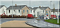
Rivenwood, Newtownards - April 2017(3)
Houses nearing completion at the Movilla Road end of the site. Not (at the time of submission) shown on the Google map but the site appears in the satellite view.
Image: © Albert Bridge
Taken: 21 Apr 2017
0.22 miles
2
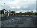
End of Stratheden Heights, Newtownards
The end of a long residential street - off the Movilla Road.
Image: © Dean Molyneaux
Taken: 22 Feb 2010
0.22 miles
3
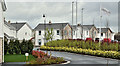
Rivenwood, Newtownards - April 2017(2)
Completed houses on the western side of Rivenwood Boulevard. Not (at the time of submission) shown on the Google map but the site appears in the satellite view. The existing Old Forge development is out of picture to the left.
Image: © Albert Bridge
Taken: 21 Apr 2017
0.24 miles
4
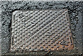
BHTEL access cover, Newtownards - April 2017(1)
An access cover on the Movilla Road close to Old Forge Lane. No foundry name visible just the BS number and “BHTEL”. The “E” is a stylised logo. Further information welcome. Image shows the inscription.
Image: © Albert Bridge
Taken: 21 Apr 2017
0.24 miles
5

BHTEL access cover, Newtownards - April 2017(2)
See Image The name and logo “BHTEL” with the stylised “E”.
Image: © Albert Bridge
Taken: 21 Apr 2017
0.24 miles