IMAGES TAKEN NEAR TO
Drummond Park, NEWTOWNARDS, BT23 8LG
Introduction
This page details the photographs taken nearby to Drummond Park, BT23 8LG by members of the Geograph project.
The Geograph project started in 2005 with the aim of publishing, organising and preserving representative images for every square kilometre of Great Britain, Ireland and the Isle of Man.

There are currently over 7.5m images from over14,400 individuals and you can help contribute to the project by visiting https://www.geograph.org.uk
Image Map
Images are licensed for reuse under creativecommons.org/licenses/by-sa/2.0
Notes
- Clicking on the map will re-center to the selected point.
- The higher the marker number, the further away the image location is from the centre of the postcode.
Image Listing (83 Images Found)
Images are licensed for reuse under creativecommons.org/licenses/by-sa/2.0
Image
Details
Distance
1
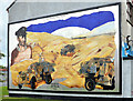
Mural, Newtownards
A mural at Queen Street depicting Blair Mayne http://www.geograph.org.uk/search.php?i=43789043.
Image: © Albert Bridge
Taken: 14 Sep 2013
0.05 miles
2
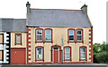
Nos 107-109 Upper Greenwell Street, Newtownards (3)
No 107 with part of 109 on the left.
Image: © Albert Bridge
Taken: 14 Sep 2013
0.06 miles
3
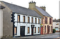
Nos 107-109 Upper Greenwell Street, Newtownards (2)
No 109 (left) and 107 Upper Greenville Street – both still vacant and awaiting redevelopment.
Image: © Albert Bridge
Taken: 14 Sep 2013
0.06 miles
4
107-109 Upper Greenwell Street, Newtownards (1)
A vacant building, offered for sale, and described by the agents as “An application for outline planning is pending for the demolition of existing dwellings and construction of new residential townhouses and apartments with associated car parking and stone walled courtyard mews (18 residential units). Amended drawings. Ref: (X/2007/1422/O)”. This photograph appears as a matter of record only. I have no connection with any of the parties involved in the sale.
Image: © Albert Bridge
Taken: 5 Dec 2012
0.06 miles
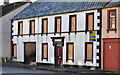
5
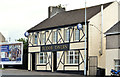
The "Tudor Tavern", Newtownards
A “Bluenose” bar, opposite the roundabout, at 6 George’s Street.
Image: © Albert Bridge
Taken: 14 Sep 2013
0.07 miles
6
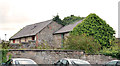
Nos 107-109 Upper Greenwell Street, Newtownards (4)
Derelict and semi-derelict outbuildings behind both properties.
Image: © Albert Bridge
Taken: 14 Sep 2013
0.07 miles
7
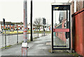
Telephone box, Zion Place, Newtownards (January 2017)
A KX100 telephone box at Zion Place.
Image: © Albert Bridge
Taken: 24 Jan 2017
0.09 miles
8
The Church of God, Newtownards
This Pentecostal Church is located in Zion Place.
Image: © Eric Jones
Taken: 17 Apr 2017
0.10 miles
9
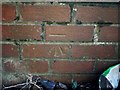
Bench Mark, Newtownards
Cut bench mark in Newtownards. It is located on a brick wall by steps that lead up to a short terrace by the roundabout at the eastern end of Frances Street. Very difficult to see!
The mark is 13.34 metres above MSL.
See also http://www.geograph.org.uk/search.php?i=11037856 for many other examples I have found.
Image: © Rossographer
Taken: 1 Apr 2010
0.10 miles
10
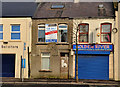
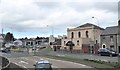
No 138 Frances Street, Newtownards
Vacant property at the roundabout end of Frances Street. Described as “Redevelopment site fronting onto the northern side of Frances Street close to Newtownards town centre. The premises currently comprise a dwelling fronting onto Frances Street with warehouse accommodation to the rear. Planning Permission has been granted for a development of 10 apartments and a mews townhouse”. This photograph appears as a matter of record only. I have no connection with any of the parties involved in the sale.
Image: © Albert Bridge
Taken: 19 Feb 2012
0.10 miles