1
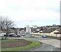
Donaghadee Road, Newtownards
Looking down towards the town centre and Scrabo Tower - which dominates the town.
Image: © Dean Molyneaux
Taken: 5 Dec 2009
0.03 miles
2
Brown's manhole cover, Newtownards (September 2017)
A Brown’s manhole cover, on the Abbey Road, close to the school.
Image: © Albert Bridge
Taken: 29 Sep 2017
0.04 miles
3
The lower end of Donaghadee Road, Newtownards
The image was taken from the roundabout on the A21 (Bangor Road).
Image: © Eric Jones
Taken: 17 Apr 2017
0.04 miles
4
Footbridge, Newtownards
A footbridge, across the Abbey Road, connecting two parts of Movilla High School. The Donaghadee Road is in the background.
Image: © Albert Bridge
Taken: 11 Aug 2011
0.04 miles
5
The Donaghadee Road, Newtownards
Terraced housing close to the western end of the Donaghadee Road, Newtownards.
Image: © Rossographer
Taken: 1 Apr 2010
0.05 miles
6
Topaz petrol station, Newtownards (September 2017)
Topaz petrol station, with a Russell’s Cellars shop, on the Donaghadee Road.
Image: © Albert Bridge
Taken: 29 Sep 2017
0.06 miles
7
Letter box, Newtownards
See
Image A slightly different view of the same EIIR letter box, showing its position at the corner of the Abbey Road and the Donaghadee Road (right).
Image: © Albert Bridge
Taken: 11 Aug 2011
0.06 miles
8
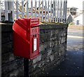
Postbox, Newtownards
Post mounted Elizabeth II postbox on the Donaghadee Road, Newtownards.
Image: © Rossographer
Taken: 1 Apr 2010
0.08 miles
9
Bench Mark, Newtownards
Cut bench mark located on the wall around Movilla High School on the Donaghadee Road, Newtownards. The mark is about 3 metres north of the junction with Abbey Road.
The mark is 23.79 metres above MSL.
See also http://www.geograph.org.uk/search.php?i=11037856 for many other examples I have found.
Image: © Rossographer
Taken: 1 Apr 2010
0.09 miles
10
Spar Store on the Bangor Road, Newtownards
Image: © Eric Jones
Taken: 17 Apr 2017
0.11 miles


