
IMAGES TAKEN NEAR TO
Saintfield Road, NEWTOWNARDS, BT23 6RW
Introduction
This page details the photographs taken nearby to Saintfield Road, BT23 6RW by members of the Geograph project.
The Geograph project started in 2005 with the aim of publishing, organising and preserving representative images for every square kilometre of Great Britain, Ireland and the Isle of Man.

There are currently over 7.5m images from over14,400 individuals and you can help contribute to the project by visiting https://www.geograph.org.uk
Image Map
Images are licensed for reuse under creativecommons.org/licenses/by-sa/2.0
Notes
- Clicking on the map will re-center to the selected point.
- The higher the marker number, the further away the image location is from the centre of the postcode.
Image Listing (3 Images Found)
Images are licensed for reuse under creativecommons.org/licenses/by-sa/2.0
Image
Details
Distance
1
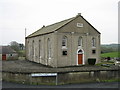
Reformed Presbyterian Church Ballymacashon
Such is the legend on the Church. It's usually spelt Ballymacashen, as on the road sign. The Church has a surrounding graveyard: it was built in 1847.
Image: © Brian Shaw
Taken: 15 Mar 2006
0.25 miles
2
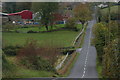
Drumlin country (5)
See Image This is the same road (Balloo-Saintfield) in another square looking towards Saintfield. The undulations are typical of the roads running through the Co Down drumlins.
Image: © Albert Bridge
Taken: 30 Oct 2006
0.25 miles
3

The Lough Road near Killinchy
The Lough Road is one of several minor roads to the west of Killinchy. It takes its name from Ballymacashen Lough (in the next square to the south). This is the view in the approximate direction of Killyleagh.
Image: © Albert Bridge
Taken: 27 Jan 2007
0.25 miles