IMAGES TAKEN NEAR TO
Bridge Street Link, NEWTOWNARDS, BT23 5YH
Introduction
This page details the photographs taken nearby to Bridge Street Link, BT23 5YH by members of the Geograph project.
The Geograph project started in 2005 with the aim of publishing, organising and preserving representative images for every square kilometre of Great Britain, Ireland and the Isle of Man.

There are currently over 7.5m images from over14,400 individuals and you can help contribute to the project by visiting https://www.geograph.org.uk
Image Map
Images are licensed for reuse under creativecommons.org/licenses/by-sa/2.0
Notes
- Clicking on the map will re-center to the selected point.
- The higher the marker number, the further away the image location is from the centre of the postcode.
Image Listing (213 Images Found)
Images are licensed for reuse under creativecommons.org/licenses/by-sa/2.0
Image
Details
Distance
1
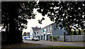
Bridge Street Link, Comber
A short stretch of through pass, bypassing The Square Image by joining Castle Street to Bridge Street (background) and providing access to a large car park off Castle Street.
Image: © Albert Bridge
Taken: 23 Oct 2013
0.01 miles
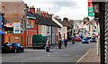
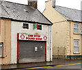
2
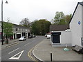
Bridge Street Link, Comber
This side street off Bridge Street has a number shops and business units.
Image: © Eric Jones
Taken: 22 Apr 2017
0.01 miles
3
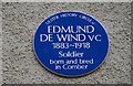
De Wind plaque, Comber
This plaque, off Bridge Street, commemorates Edmund De Wind who was awarded a posthumous Victoria Cross during WW1 http://www.ulsterhistory.co.uk/deWind.htm.
Image: © Albert Bridge
Taken: 6 Nov 2007
0.02 miles
4

Assembly election poster, Comber - April 2016(1)
Bridge Street Link. Democratic Unionist Party.
Image: © Albert Bridge
Taken: 19 Apr 2016
0.02 miles
5
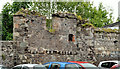
Old wall, Comber
The remains of an old wall, beside the car park, at the Bridge Street Link. A walking guide to Comber has this quotation “Proceed out to Bridge Street via Bridge Street Link, passing old ruined walls which belonged to the Allen traction engine works”.
Image: © Albert Bridge
Taken: 26 Jun 2012
0.03 miles
6
Bridge Street, Comber
Bridge Street is the road into Comber from the Newtownards direction. The Square is at the traffic lights (middle right). The bridge is this one Image
Image: © Albert Bridge
Taken: 11 Sep 2010
0.03 miles
7
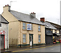
No 25 Bridge Street, Comber
A vacant house offered for sale. Described on the agent’s website as “An opportunity exists to acquire a large town house and site for four apartments situated just yards from Comber Square with ample on site car parking. Full planning permission has been granted for six apartments which includes the demolition of the existing townhouse and replacement with two apartments.” This photograph appears as a matter of record only. I have no connection with any of the parties involved in the sale. No 27 Image is on the left.
Image: © Albert Bridge
Taken: 4 Jan 2012
0.03 miles
8
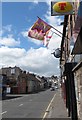
Bridge Street, Comber
The image was taken from the front of the First and Last PH. This is a popular Loyalist pub.
Image: © Eric Jones
Taken: 2 Aug 2013
0.03 miles
9
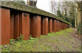
Shoring, Comber
Much of the Enler River passes unseen through Comber. Its steep banks have been piled and shored (see Image). This example is at the back of the leisure centre. The river and riverside path are behind the shoring.
Image: © Albert Bridge
Taken: 20 Feb 2012
0.03 miles
10
No 27 Bridge Street, Comber
A vacant shop offered for sale. The agents’ website does not (at the time of submission) refer to a “development opportunity”. No 25 Image is on the right. This photograph appears as a matter of record only. I have no connection with any of the parties involved in the sale.
Image: © Albert Bridge
Taken: 4 Jan 2012
0.04 miles