
IMAGES TAKEN NEAR TO
Short Street, NEWTOWNARDS, BT23 4GP
Introduction
This page details the photographs taken nearby to Short Street, BT23 4GP by members of the Geograph project.
The Geograph project started in 2005 with the aim of publishing, organising and preserving representative images for every square kilometre of Great Britain, Ireland and the Isle of Man.

There are currently over 7.5m images from over14,400 individuals and you can help contribute to the project by visiting https://www.geograph.org.uk
Image Map
Images are licensed for reuse under creativecommons.org/licenses/by-sa/2.0
Notes
- Clicking on the map will re-center to the selected point.
- The higher the marker number, the further away the image location is from the centre of the postcode.
Image Listing (205 Images Found)
Images are licensed for reuse under creativecommons.org/licenses/by-sa/2.0
Image
Details
Distance
1
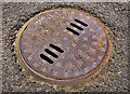
Adams manhole cover, Newtownards
An Adams Hydraulic Limited manhole cover, in Robert Street, close to a site where building work has just started. After 120 years the business is still trading http://www.adamshydraulics.co.uk/content/products/grp/grp.php. For other photographs on Geograph see http://www.geograph.org.uk/search.php?i=22621065.
Image: © Albert Bridge
Taken: 26 Jun 2011
0.03 miles
2
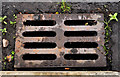
McKeown grating cover, Newtownards
See Image Another McKeown’s Grosvenor Foundry http://www.geograph.org.uk/search.php?i=23884431 grating but without the patent number. This one is at the Robert Street end of Brewery Lane.
Image: © Albert Bridge
Taken: 11 Aug 2011
0.03 miles
3
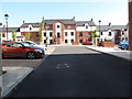
The Old Market Square - a gated residential development
Situated off East Street, this is a recent development in what was a twilight zone behind the town's Central Business District.
Image: © Eric Jones
Taken: 21 May 2012
0.04 miles
4
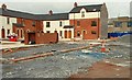
New apartments, Newtownards
New apartments and townhouses, in West Street, being built on the site of the old market yard Image
Image: © Albert Bridge
Taken: 23 Mar 2008
0.04 miles
5
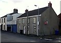
Houses, Newtwonards
Houses on West Street in Newtownards. There is an old stone on one of the grey houses - see Image
Image: © Rossographer
Taken: 1 Apr 2010
0.04 miles
6
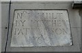
Stone plaque, Newtownards
Stone plaque built into a house in West Street, Newtownards - see Image
The house that the plaque is on is not number 38, so this must have been from an earlier property (perhaps not even on this street). The full text reads:
"No. 38 built by Matthew Patterson 1769".
Image: © Rossographer
Taken: 1 Apr 2010
0.04 miles
7
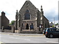
Newtownards Second Presbyterian Church, Upper Mary Street
Confusingly, the third Presbyterian church to be built at Newtownards, it was called the 2nd Presbyterian. Dating from 1771 it was a congregation of Anti-Burgher Seceders a conservative group who split from Seceders over an oath to be taken by burghers in Scottish towns.
Image]
Image: © Eric Jones
Taken: 2 Aug 2013
0.05 miles
8
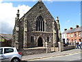
Second Presbyterian Church, Upper Mary Street
Confusingly, the third Presbyterian church to be built at Newtownards, it was called the 2nd Presbyterian. Dating from 1771 it was a congregation of Anti-Burgher Seceders a conservative group who split from Seceders over an oath to be taken by burghers in Scottish towns.
Image]
Image: © Eric Jones
Taken: 2 Aug 2013
0.05 miles
9
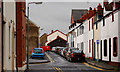
Robert Street, Newtownards
A very narrow street, running parallel to West Street, close to the back of the bus station. Wide enough to take a car but not a lorry.
Image: © Albert Bridge
Taken: 7 Feb 2011
0.06 miles
10
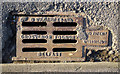
Gully grating, Newtownards
Grating on Mark Street in Newtownards. From the Grosvenor Foundry of J. & J. McKeown in Belfast, it also features the patent number - 34915/30. This was one of several noticed in the area.
Image: © Rossographer
Taken: 1 Jun 2011
0.06 miles