
IMAGES TAKEN NEAR TO
The Chanderies, NEWTOWNARDS, BT22 2TA
Introduction
This page details the photographs taken nearby to The Chanderies, BT22 2TA by members of the Geograph project.
The Geograph project started in 2005 with the aim of publishing, organising and preserving representative images for every square kilometre of Great Britain, Ireland and the Isle of Man.

There are currently over 7.5m images from over14,400 individuals and you can help contribute to the project by visiting https://www.geograph.org.uk
Image Map
Images are licensed for reuse under creativecommons.org/licenses/by-sa/2.0
Notes
- Clicking on the map will re-center to the selected point.
- The higher the marker number, the further away the image location is from the centre of the postcode.
Image Listing (37 Images Found)
Images are licensed for reuse under creativecommons.org/licenses/by-sa/2.0
Image
Details
Distance
4
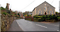
The Newtownards Road, Greyabbey (1)
The main road into Greyabbey from Newtownards. Greyabbey 1st Presbyterian (Unitarian) church (rebuilt in 1860) is on the right. Trinity (2nd)) Presbyterian church of 1827 is in the background towards the middle left.
See also Image
Image: © Albert Bridge
Taken: 30 Mar 2011
0.16 miles
5
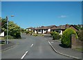
Strangford View, Greyabbey
This is a recently built estate on the western outskirts of the village.
Image: © Eric Jones
Taken: 2 Aug 2013
0.16 miles
6
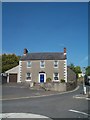
Georgian house on The Square at Greyabbey
Image: © Eric Jones
Taken: 22 May 2012
0.19 miles
7

Location of OS Flush Bracket 3478 - Greyabbey
Image: © thejackrustles
Taken: 2 Feb 2023
0.19 miles
8
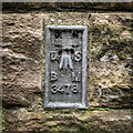
Flush Bracket, Greyabbey
Flush bracket set into the northern side of Trinity Presbyterian Church in the centre of Greyabbey.
The number on the bracket is OSBM 3478.
The mark is 6.24 metres above MSL.
Image: © Rossographer
Taken: 29 Dec 2024
0.19 miles
9

Flush Bracket, Greyabbey
Flush bracket set into the northern side of Trinity Presbyterian Church in the centre of Greyabbey.
The number on the bracket is OSBM 3478.
The mark is 6.24 metres above MSL.
A flush bracket is a type of bench mark set onto the face of a building. See also http://www.geograph.org.uk/search.php?i=11037856 for many other examples I have found.
Image: © Rossographer
Taken: 3 May 2010
0.19 miles
10
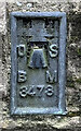
OS Flush Bracket 3478 - Greyabbey
https://www.bench-marks.org.uk/bm68185
Image: © thejackrustles
Taken: 2 Feb 2023
0.19 miles