IMAGES TAKEN NEAR TO
Newtownards Road, NEWTOWNARDS, BT22 2QJ
Introduction
This page details the photographs taken nearby to Newtownards Road, BT22 2QJ by members of the Geograph project.
The Geograph project started in 2005 with the aim of publishing, organising and preserving representative images for every square kilometre of Great Britain, Ireland and the Isle of Man.

There are currently over 7.5m images from over14,400 individuals and you can help contribute to the project by visiting https://www.geograph.org.uk
Image Map
Images are licensed for reuse under creativecommons.org/licenses/by-sa/2.0
Notes
- Clicking on the map will re-center to the selected point.
- The higher the marker number, the further away the image location is from the centre of the postcode.
Image Listing (3 Images Found)
Images are licensed for reuse under creativecommons.org/licenses/by-sa/2.0
Image
Details
Distance
1
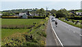
The Newtownards Road near Greyabbey
The Newtownards Road north of Greyabbey.
Image: © Rossographer
Taken: 9 May 2020
0.19 miles
2
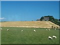
Sheep grazing land and crop land outside Greyabbey
Image: © Eric Jones
Taken: 2 Aug 2013
0.20 miles
3
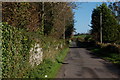
The Spring Lane near Greyabbey (1)
The Spring Lane runs from just south of the Mount Stewart estate near Greyabbey (sometimes “Greba”) to the Carrowdore-Greyabbey road. It is mainly agricultural country. The Mount Stewart estate is behind the wall on the left.
Image: © Albert Bridge
Taken: 23 Oct 2006
0.23 miles