
IMAGES TAKEN NEAR TO
Cunningburn Road, NEWTOWNARDS, BT22 2AN
Introduction
This page details the photographs taken nearby to Cunningburn Road, BT22 2AN by members of the Geograph project.
The Geograph project started in 2005 with the aim of publishing, organising and preserving representative images for every square kilometre of Great Britain, Ireland and the Isle of Man.

There are currently over 7.5m images from over14,400 individuals and you can help contribute to the project by visiting https://www.geograph.org.uk
Image Map
Images are licensed for reuse under creativecommons.org/licenses/by-sa/2.0
Notes
- Clicking on the map will re-center to the selected point.
- The higher the marker number, the further away the image location is from the centre of the postcode.
Image Listing (10 Images Found)
Images are licensed for reuse under creativecommons.org/licenses/by-sa/2.0
Image
Details
Distance
1

Former Cunningburn Mill near Newtownards
The Cunningburn Road runs off the Newtownards – Portaferry road in the direction of Millisle and Donaghadee. The old Cunningburn Mill is on the right. Built in 1778, it and the adjacent cottages are now in residential use.
Image: © Albert Bridge
Taken: 19 May 2008
0.04 miles
2

Thatched cottage, Cunningburn near Newtownards
A listed thatched cottage on the Cunningburn Road, previously seen (middle) in Image (May 2008). This link is to the official listing http://www.doeni.gov.uk/niea/built/buildview?id=2458&js=true which, inter alia, records the house appearing on “a map drawn up in 1777, when the townland of Cunningburn was part of the estate of Alexander Stewart of Mount Stewart, the father of the future Marquis of Londonderry”.
Image: © Albert Bridge
Taken: 11 Jun 2012
0.05 miles
3

Hugh Smith weighbridge near Newtownards (1)
This seems to be a small weighbridge, at the former Cunningburn corn and flax mill Image, made by Hugh Smith & Co, Glasgow. The business was founded in 1875 and has a history which is too long for this caption. Image shows the maker’s name.
Image: © Albert Bridge
Taken: 11 Jun 2012
0.05 miles
4

Hugh Smith weighbridge near Newtownards (2)
See Image The inscription showing the maker’s name.
Image: © Albert Bridge
Taken: 11 Jun 2012
0.05 miles
5
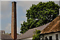
Former mill chimney, Cunningburn, Newtownards
The chimney of the former Cunningburn corn and flax mill Image fully described in this link http://www.doeni.gov.uk/niea/built/buildview?id=4268&js=true. The mill is thought to date from 1776 when it would have been water powered. The chimney is likely to be from a much later date.
Image: © Albert Bridge
Taken: 11 Jun 2012
0.05 miles
6

Gateposts, Cunningburn near Newtownards (June 2019)
A pair of gate posts, both with conical tops, along this part of the Cunningburn Road Image There are several others in the immediate area.
Image: © Albert Bridge
Taken: 14 Jun 2019
0.08 miles
7

The Cunningburn Road near Newtownards
The Cunningburn Road runs off the Newtownards – Portaferry road, through agricultural land, in the direction of Millisle and Donaghadee. This is a tree-lined part of the road just past the old mill Image
Image: © Albert Bridge
Taken: 19 May 2008
0.08 miles
8

The Cunningburn Road, Cunningburn near Newtownards (June 2019)
Image: © Albert Bridge
Taken: 14 Jun 2019
0.11 miles
9
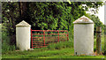
Gateposts, Cunningburn near Newtownards
A gate and two traditional gates posts, with conical tops (explained in Image), on the eastern side of the Cunningburn Road past this cottage Image
Image: © Albert Bridge
Taken: 11 Jun 2012
0.18 miles
10
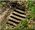
Union Foundry grating cover, Cunningburn near Newtownards
Another example of a grating cover cast by Gregg Sons and Phenix, the Union Foundry, Belfast. This one, partly concealed by grass, is on the Cunningburn Road almost opposite these gateposts Image For others click the “Union Foundry” tag.
Image: © Albert Bridge
Taken: 11 Jun 2012
0.19 miles