IMAGES TAKEN NEAR TO
Shore Road, NEWTOWNARDS, BT22 1LA
Introduction
This page details the photographs taken nearby to Shore Road, BT22 1LA by members of the Geograph project.
The Geograph project started in 2005 with the aim of publishing, organising and preserving representative images for every square kilometre of Great Britain, Ireland and the Isle of Man.

There are currently over 7.5m images from over14,400 individuals and you can help contribute to the project by visiting https://www.geograph.org.uk
Image Map
Images are licensed for reuse under creativecommons.org/licenses/by-sa/2.0
Notes
- Clicking on the map will re-center to the selected point.
- The higher the marker number, the further away the image location is from the centre of the postcode.
Image Listing (45 Images Found)
Images are licensed for reuse under creativecommons.org/licenses/by-sa/2.0
Image
Details
Distance
2
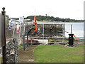
Civil engineering works at the southern quay
Image: © Eric Jones
Taken: 20 Jul 2017
0.06 miles
3
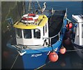
The potter Mizpah N455 tied up at Portaferry Pier
This boat which uses pots to catch lobsters and crabs was built at Weymouth in 1979. The heron posing on the cabin roof is real. Nowadays, potting is the only form of commercial fishing permitted within the lough. Potting occurs in water less than 10 m deep in the Narrows.
Mizpah is Hebrew for "Lord watch over me".
Image: © Eric Jones
Taken: 23 Aug 2017
0.07 miles
4
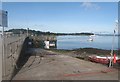
Portaferry Pier
The Strangford-Portaferry ferry can be seen in the background right making for Strangford.
Image: © Eric Jones
Taken: 23 Aug 2017
0.07 miles
5
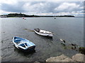
Rowing boats below Shore Road one hour after High Water
Image: © Eric Jones
Taken: 23 Aug 2017
0.09 miles
6
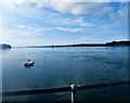
Fast flood currents off Portaferry Pier
Flood and ebb currents can reach a speed of 8 knots in The Narrows. The decommissioned SeaGen turbine can be seen in the distance.
Image: © Eric Jones
Taken: 23 Aug 2017
0.09 miles
7
Mooring area between the Slipway and the Saltpans Apartments
Image: © Eric Jones
Taken: 23 Aug 2017
0.12 miles
8
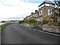
Houses on the southern outskirts of Portaferry
These are located on Shore Road.
Image: © Eric Jones
Taken: 20 Jul 2017
0.12 miles
9
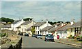
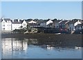
The Shore Road, Portaferry
Portaferry has become famous for these modern houses overlooking Strangford Lough. They were built in a style similar to the ones they replaced. See also Image
Image: © Albert Bridge
Taken: 9 Jun 2008
0.12 miles
10
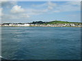
Fast moving currents in the Strangford Narrows
The Narrows experience some of the world's fastest tidal currents. The settlement in the background is Portaferry.
Image: © Eric Jones
Taken: 8 Jul 2012
0.12 miles