IMAGES TAKEN NEAR TO
The Square, NEWTOWNARDS, BT22 1HR

Introduction

This page details the photographs taken nearby to The Square, BT22 1HR by members of the Geograph project.

The Geograph project started in 2005 with the aim of publishing, organising and preserving representative images for every square kilometre of Great Britain, Ireland and the Isle of Man.

There are currently over 7.5m images from over14,400 individuals and you can help contribute to the project by visiting https://www.geograph.org.uk

Image Map


Images are licensed for reuse under creativecommons.org/licenses/by-sa/2.0
Notes
  • Clicking on the map will re-center to the selected point.
  • The higher the marker number, the further away the image location is from the centre of the postcode.

Image Listing (15 Images Found)

Images are licensed for reuse under creativecommons.org/licenses/by-sa/2.0
Image
Details
Distance
1
Cloughey Presbyterian Church
The village of Cloughey is 75% Protestant.
Image: © Eric Jones Taken: 2 Aug 2013
0.05 miles
2
Manse Road, Cloughey
This is a minor road which under various names follows the coastline towards Portaferry. The A2 takes a more direct inland route to the town.
Image: © Eric Jones Taken: 2 Aug 2013
0.05 miles
3
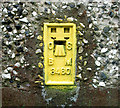
Flush Bracket, Cloghy
Flush bracket located on the northern side of Cloghy Presbyterian Church Image The number on the bracket is OSBM 3480. The mark is 6.48 metres above MSL. A flush bracket is a type of bench mark set onto the face of a building. See also http://www.geograph.org.uk/search.php?i=11037856 for many other examples I have found.
Image: © Rossographer Taken: 10 Jul 2010
0.06 miles
4
Cloughey Presbyterian Church
The Presbyterian Church in Cloughey was built in 1842 on a plot of ground between the road and the sea which had been donated by John Echlin Esq. of Echlinville and Rev. IR Echlin, previous services having been held in nearby Kirkistown Castle.
Image: © Sue Adair Taken: 23 Mar 2011
0.07 miles
5
Ukrainian flag, Cloughey
Support for Ukraine in the garden of a house at the southern end of Cloughey Bay.
Image: © Rossographer Taken: 5 Feb 2023
0.09 miles
6
The beach at Cloughey
Image: © Eric Jones Taken: 2 Aug 2013
0.15 miles
7
Bridge and river, Cloughey
Road bridge over a small river which enters the sea at the southern end of Cloughey Bay.
Image: © Rossographer Taken: 5 Feb 2023
0.18 miles
8
Pasture land south of the Portaferry Road
Image: © Eric Jones Taken: 2 Aug 2013
0.18 miles
9
Cloghy Bay
Image: © Michael Parry Taken: 15 Apr 2005
0.18 miles
10
South end of Cloughey Bay
Image: © Oliver Dixon Taken: 9 May 2007
0.20 miles