
IMAGES TAKEN NEAR TO
Stockbridge Lane, DONAGHADEE, BT21 0RA
Introduction
This page details the photographs taken nearby to Stockbridge Lane, BT21 0RA by members of the Geograph project.
The Geograph project started in 2005 with the aim of publishing, organising and preserving representative images for every square kilometre of Great Britain, Ireland and the Isle of Man.

There are currently over 7.5m images from over14,400 individuals and you can help contribute to the project by visiting https://www.geograph.org.uk
Image Map
Images are licensed for reuse under creativecommons.org/licenses/by-sa/2.0
Notes
- Clicking on the map will re-center to the selected point.
- The higher the marker number, the further away the image location is from the centre of the postcode.
Image Listing (4 Images Found)
Images are licensed for reuse under creativecommons.org/licenses/by-sa/2.0
Image
Details
Distance
1
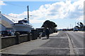
Ship Ahoy
A large cabin cruiser parked in a small garden on the Warren Road (A2) near Donaghadee.
Image: © Robert Ashby
Taken: 30 Mar 2016
0.13 miles
2
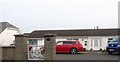
Bungalow on the East side of Warren Road
This house backs on the shores of Sandy Bay.
Image: © Eric Jones
Taken: 28 Mar 2017
0.14 miles
3
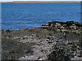
Shoreline near Portavo
The shore near Portavo, just off the Warren Road between Orlock and Donaghdee. The Copeland Islands are in the background across the Copeland Sound.
Image: © Rossographer
Taken: 17 Mar 2008
0.17 miles
4
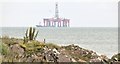
The coast near Portavo, Groomsport/Donaghadee (July 2015)
The Irish Sea occupies a large part of this square. The rocky coast (standard here) is close to the Bangor – Donaghadee road. The oil rig “Byford Dolphin” is out on sea trials (background).
Image: © Albert Bridge
Taken: 18 Jul 2015
0.23 miles