IMAGES TAKEN NEAR TO
Kylestone Road, DONAGHADEE, BT21 0PR
Introduction
This page details the photographs taken nearby to Kylestone Road, BT21 0PR by members of the Geograph project.
The Geograph project started in 2005 with the aim of publishing, organising and preserving representative images for every square kilometre of Great Britain, Ireland and the Isle of Man.

There are currently over 7.5m images from over14,400 individuals and you can help contribute to the project by visiting https://www.geograph.org.uk
Image Map
Images are licensed for reuse under creativecommons.org/licenses/by-sa/2.0
Notes
- Clicking on the map will re-center to the selected point.
- The higher the marker number, the further away the image location is from the centre of the postcode.
Image Listing (4 Images Found)
Images are licensed for reuse under creativecommons.org/licenses/by-sa/2.0
Image
Details
Distance
1
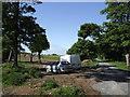
Pipeline laying by Kylestone Road
Image: © Jonathan Billinger
Taken: 17 May 2007
0.10 miles
2
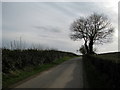
Kylestone Road, near Portavo
Looking south towards the High Bangor Road.
Image: © Rossographer
Taken: 24 Feb 2008
0.14 miles
3
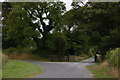
Kylestone Road near Portavo
The Kylestone Road is an unclassified road running from the High Bangor Road, Donaghadee to the coast road near Orlock. This is it at the rear of the Portavo estate. The road turns sharply to the left. The gates mark the side entrance to the estate.
Image: © Albert Bridge
Taken: 23 Jul 2006
0.20 miles
4
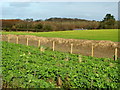
Fields, near Portavo
Cabbages growing in the foreground - looking towards Portavo.
Image: © Rossographer
Taken: 24 Feb 2008
0.22 miles