IMAGES TAKEN NEAR TO
William Street, DONAGHADEE, BT21 0HL

Introduction

This page details the photographs taken nearby to William Street, BT21 0HL by members of the Geograph project.

The Geograph project started in 2005 with the aim of publishing, organising and preserving representative images for every square kilometre of Great Britain, Ireland and the Isle of Man.

There are currently over 7.5m images from over14,400 individuals and you can help contribute to the project by visiting https://www.geograph.org.uk

Image Map


Images are licensed for reuse under creativecommons.org/licenses/by-sa/2.0
Notes
  • Clicking on the map will re-center to the selected point.
  • The higher the marker number, the further away the image location is from the centre of the postcode.

Image Listing (250 Images Found)

Images are licensed for reuse under creativecommons.org/licenses/by-sa/2.0
  • ...
Image
Details
Distance
1
Sign, Railway Street, Donaghadee
The railway to Donaghadee closed in 1950 but the town is still littered with evidence of its existence. This street is very close to the old station (long since demolished). See http://www.geograph.org.uk/search.php?i=3469971 for a variety of related images.
Image: © Rossographer Taken: 21 Aug 2008
0.01 miles
2
Railway Street, Donaghadee (2)
See Image The cast name sign, last seen in August 2008 Image, still survives.
Image: © Albert Bridge Taken: 12 May 2011
0.03 miles
3
Saltworks Street, Donaghadee (2)
See Image The sign at the Meetinghouse Street end.
Image: © Albert Bridge Taken: 12 May 2011
0.04 miles
4
Railway Street, Donaghadee (1)
The railway closed in 1950 but the street’s name keeps its memory alive. Railway Street runs from Meetinghouse Street/William Street towards where the railway used to be. A council yard now occupies part of the site of the old station yard (background). Continue to Image
Image: © Albert Bridge Taken: 12 May 2011
0.05 miles
5
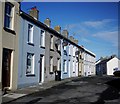
William Street, Donaghadee
Close to the town centre in Donaghadee, William Street is mostly composed of 19th Century terraced housing.
Image: © Rossographer Taken: 1 Apr 2010
0.05 miles
6
Former bus station, Donaghadee - November 2014(1)
See Image (July 2010) and Image The Ulsterbus bus station and sub-depot (Railway Street) closed in September 2013. The building and yard remain unused and padlocked. Image shows the closure notice.
Image: © Albert Bridge Taken: 29 Nov 2014
0.05 miles
7
Wheelie bin, Donaghadee (November 2014)
An abandoned commercial wheelie bin inside the yard of the former bus station Image
Image: © Albert Bridge Taken: 29 Nov 2014
0.05 miles
8
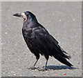
Rook, Donaghadee
A rook http://en.wikipedia.org/wiki/Rook_(bird) at the car park behind the bus station – one of several places in Donaghadee where they (and gulls) often gather. Rooks are sometimes confused with crows – this Image can be used for comparison.
Image: © Albert Bridge Taken: 7 Aug 2013
0.05 miles
9
Gulls, Donaghadee (3)
Four black-headed gulls (part of a mixed flock) at the car park behind the bus station – one of several places in Donaghadee where they (and rooks) often gather.
Image: © Albert Bridge Taken: 7 Aug 2013
0.05 miles
10
Navelwort, Donaghadee
Growing in the wall between the bus station and the marina.
Image: © Albert Bridge Taken: 16 Jun 2013
0.06 miles
  • ...