IMAGES TAKEN NEAR TO
Downshire Court, BANGOR, BT20 5RT
Introduction
This page details the photographs taken nearby to Downshire Court, BT20 5RT by members of the Geograph project.
The Geograph project started in 2005 with the aim of publishing, organising and preserving representative images for every square kilometre of Great Britain, Ireland and the Isle of Man.

There are currently over 7.5m images from over14,400 individuals and you can help contribute to the project by visiting https://www.geograph.org.uk
Image Map
Images are licensed for reuse under creativecommons.org/licenses/by-sa/2.0
Notes
- Clicking on the map will re-center to the selected point.
- The higher the marker number, the further away the image location is from the centre of the postcode.
Image Listing (71 Images Found)
Images are licensed for reuse under creativecommons.org/licenses/by-sa/2.0
Image
Details
Distance
1
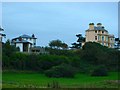
Thalassa
The house on the right is called Thalassa; it sits prominently just above the coastal path between Brompton and Smelt Mill Bay (Stricklands Glen). Currently under threat of demolition it has lain empty for many years - developers want to replace it with something like that on the left (which I actually like - I just wish they wouldn't knock down delightful period properties!).
Image: © Rossographer
Taken: 7 Oct 2007
0.02 miles
2
![Thalassa [2]](https://s3.geograph.org.uk/photos/62/69/626995_9925deb1_120x120.jpg)
Thalassa [2]
As predicted in Image, 'Thalassa' has been demolished.
Image: © Rossographer
Taken: 3 Dec 2007
0.03 miles
3
![Thalassa [3]](https://s0.geograph.org.uk/photos/63/01/630172_686aad27_120x120.jpg)
Thalassa [3]
An earlier picture of the fine property 'Thalassa' prior to demolition (see Image). Although derelict, with smashed and boarded up windows, it is still possible to appreciate how grand this house once was.
Picture taken from the water (from the 'Blue Aquarius' http://www.geograph.org.uk/search.php?i=1991006 ) and copyright PMcC not myself.
Image: © P McCarthy
Taken: 6 Jul 2006
0.05 miles
4
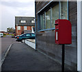
Postbox, Bangor
Post mounted Elizabeth II postbox (BT20 274) at Stricklands Care Village (Northern Ireland Institute for the Disabled) on the Downshire Road in Bangor.
Image: © Rossographer
Taken: 20 Apr 2012
0.06 miles
5
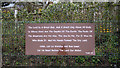
Religious message, Bangor
Psalm 95 on a fence at Brompton, Bangor. It appeared when this one Image nearby was removed.
Image: © Rossographer
Taken: 25 Mar 2020
0.06 miles
6
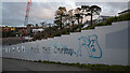
Graffiti, Bangor
Graffiti related to the Coronavirus restrictions, this time on hoardings at Brompton in Bangor.
A point of note - there has been no full "curfew" in Northern Ireland. Between 26th December 2020 and the 2nd January 2021 no gatherings - indoor or outdoor - were permitted between 20:00 and 06:00, but individuals could still leave their homes.
Image: © Rossographer
Taken: 3 Jan 2021
0.08 miles
7

Berries and bugs, Bangor
Some bright red hawthorn berries ripening on the North Down Coastal Path near Smelt Mill Bay in Bangor. I hadn't noticed the green bug on the bottom right of this picture when I was taking it. Thanks to Keith Edkins http://www.geograph.org.uk/profile/11413 for identifying it as a nymph (immature stage) of the Hawthorn shield-bug Acanthosoma haemorrhoidale and also for spotting a second hiding under a leaf in the bottom left of picture.
Image: © Rossographer
Taken: 27 Aug 2008
0.08 miles
8

Blackberries, Bangor
Blackberries on the North Down Coastal Path near Smelt Mill Bay, Bangor.
Image: © Rossographer
Taken: 27 Aug 2008
0.08 miles
9
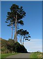
Trees, North Down Coastal Path
Tall pine trees on the North Down Coastal Path near Downshire Road.
Image: © Rossographer
Taken: 29 Mar 2009
0.08 miles
10
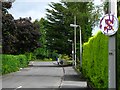
Brompton Road, Bangor
One end of Brompton Road, near the junction with Downshire Road. The road is a cul-de-sac and leads to the shore of Belfast Lough - see Image
Image: © Rossographer
Taken: 8 Jul 2008
0.09 miles