IMAGES TAKEN NEAR TO
Morningside, BANGOR, BT20 5PD
Introduction
This page details the photographs taken nearby to Morningside, BT20 5PD by members of the Geograph project.
The Geograph project started in 2005 with the aim of publishing, organising and preserving representative images for every square kilometre of Great Britain, Ireland and the Isle of Man.

There are currently over 7.5m images from over14,400 individuals and you can help contribute to the project by visiting https://www.geograph.org.uk
Image Map
Images are licensed for reuse under creativecommons.org/licenses/by-sa/2.0
Notes
- Clicking on the map will re-center to the selected point.
- The higher the marker number, the further away the image location is from the centre of the postcode.
Image Listing (62 Images Found)
Images are licensed for reuse under creativecommons.org/licenses/by-sa/2.0
Image
Details
Distance
1
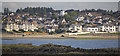
Ballyholme Esplanade, Bangor
Ballyholme Esplanade and beach. Note the windmill stump near the centre of the picture - now a converted house.
Image: © Rossographer
Taken: 15 Jul 2015
0.05 miles
2
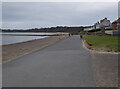
The North Down Coastal Path at Ballyholme
The path at Ballyholme beach on the eastern side of Bangor. Here walkers can choose between a wide promenade or (at low tide) the beach. Cyclists can continue here for a few hundred metres but must leave the path at Banks Lane - it is possible (but dangerous at times) to continue on towards Groomsport, Orlock and Donaghadee via the A2 road.
Image: © Rossographer
Taken: 13 Feb 2023
0.05 miles
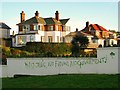
3
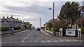
Morningside, Bangor
Residential street running from the Groomsport Road to Ballyholme beach in Bangor. Taken during the Covid-19 crisis, the banner on the right is in support of NHS workers. See also Image
Image: © Rossographer
Taken: 24 Mar 2020
0.06 miles
4
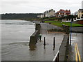
Unusually high tide, Ballyholme
A very high tide at Ballyholme in Bangor, covering almost every inch of beach under several feet of water. The water has come up around the bridge Image making it impassable. Due to tidal affect and recent heavy rains the little river is also very high. There was very little wind - if the same situation had occurred during stormy weather I imagine that there would have been considerable flooding and damage.
Image: © Rossographer
Taken: 13 Jan 2008
0.06 miles
5
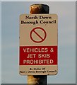
Sign, Ballyholme Beach
One of the better by-laws passed by North Down Borough Council was to ban the launching of jet skis from beaches several years ago. This particular order seems to have been extremely successful.
Vehicles may be banned from Ballyholme Beach but the occasional motorcycle makes its way onto the sand.
Image: © Rossographer
Taken: 12 Feb 2009
0.06 miles
6
Graffiti, Bangor
Graffiti on a wall on Ballyholme Esplanade. Note the spelling mistake.
Image: © Rossographer
Taken: 12 Feb 2009
0.06 miles
7
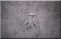
Bench Mark, Bangor
Cut bench mark on the Ballyholme Bridge on the Groomsport Road in Bangor.
The mark is 5.27 metres above MSL.
See also http://www.geograph.org.uk/search.php?i=11037856 for many other examples I have found.
Image: © Rossographer
Taken: 13 Mar 2010
0.06 miles
8
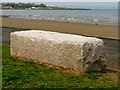
Bench, Ballyholme beach
Memorial bench overlooking Ballyholme beach in Bangor. Made of a solid piece of granite, the bench has the following inscription on top:
"I must go down to the sea again, for the call of the running tide
is a wild call and a clear call that may not be denied;
and all I ask is a windy day with the white clouds flying,
and the flung spray and the blown spume, and the sea-gulls crying."
Image: © Rossographer
Taken: 10 May 2008
0.06 miles
9
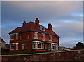
Red Hall, Ballyholme
Fine large red-bricked house built c1920 close to the shoreline.
Image: © Rossographer
Taken: 29 Oct 2007
0.07 miles
10
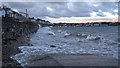
Promenade, Ballyholme
A high tide and brisk onshore breeze makes for difficult walking conditions as the waves crash against the promenade at Ballyholme beach, Bangor.
Image: © Rossographer
Taken: 9 Jan 2020
0.08 miles